
Mapa topográfico Putanges-Pont-Écrepin
Mapa interativo
Clique no mapa para exibir a altitude.
Sobre este mapa
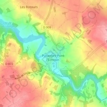
Nome: Mapa topográfico Putanges-Pont-Écrepin, altitude, relevo.
Altitude média: 186 m
Altitude mínima: 119 m
Altitude máxima: 248 m
Cependant, il faut prendre put au sens non pas de « sale », mais plutôt de « mauvais » (signification que sale peut aussi avoir). Deux anciens lieux-dits de Lisieux portent le nom de Putangle (de Puto angulo 1200, Putangle 1267) et Bonangle (Bone Angle 1293, Bon Angle 1326), ce dernier devenu aujourd'hui la rue Bon Ange. Il s'agit de deux coins de l'ancienne île Saint-Dominique sur la Touques, le put angle « mauvais coin » est formé par le coude dangereux ou malcommode de la rivière, et le bon angle « bon coin » s'oppose ainsi à lui. La topographie à Putanges est identique puisqu'il est situé sur une courbe prononcée de l'Orne.
Outros mapas topográficos
Clique em um mapa para visualizar sua topografia, sua altitude e seu relevo.
Le Ray
France > Normandie > Orne > Putanges-le-Lac > La Forêt-Auvray
Le Ray, La Forêt-Auvray, Putanges-le-Lac, Argentan, Orne, Normandie, France métropolitaine, 61210, France
Altitude média: 164 m
La Fresnaye-au-Sauvage
France > Normandie > Orne > Putanges-le-Lac
La Fresnaye-au-Sauvage, Putanges-le-Lac, Argentan, Orne, Normandie, France métropolitaine, 61210, France
Altitude média: 214 m
Rabodanges
France > Normandie > Orne > Putanges-le-Lac
Rabodanges, Putanges-le-Lac, Argentan, Orne, Normandie, France métropolitaine, 61210, France
Altitude média: 188 m
Les Courtils
France > Normandie > Orne > Putanges-le-Lac > Putanges-Pont-Écrepin
Les Courtils, Putanges-Pont-Écrepin, Putanges-le-Lac, Argentan, Orne, Normandie, France métropolitaine, 61210, France
Altitude média: 186 m
Les Rotours
France > Normandie > Orne > Putanges-le-Lac
Les Rotours, Putanges-le-Lac, Argentan, Orne, Normandie, France métropolitaine, 61210, France
Altitude média: 191 m
Le Hamel
France > Normandie > Orne > Putanges-le-Lac > La Forêt-Auvray > Le Hamel
Le Hamel, La Forêt-Auvray, Putanges-le-Lac, Argentan, Orne, Normandie, France métropolitaine, 61210, France
Altitude média: 173 m
Le Perrey
France > Normandie > Orne > Putanges-le-Lac > Rabodanges
Le Perrey, Rabodanges, Putanges-le-Lac, Argentan, Orne, Normandie, France métropolitaine, 61210, France
Altitude média: 177 m
Le Chenay
France > Normandie > Orne > Putanges-le-Lac > Putanges-Pont-Écrepin
Le Chenay, Putanges-Pont-Écrepin, Putanges-le-Lac, Argentan, Orne, Normandie, France métropolitaine, 61210, France
Altitude média: 188 m
Saint-Aubert-sur-Orne
France > Normandie > Orne > Putanges-le-Lac
Saint-Aubert-sur-Orne, Putanges-le-Lac, Argentan, Orne, Normandie, France métropolitaine, 61210, France
Altitude média: 200 m
Sainte-Croix-sur-Orne
France > Normandie > Orne > Putanges-le-Lac
Sainte-Croix-sur-Orne, Putanges-le-Lac, Argentan, Orne, Normandie, France métropolitaine, 61210, France
Altitude média: 186 m