
Mapa topográfico Northern Liravi RD
Mapa interativo
Clique no mapa para exibir a altitude.
Sobre este mapa
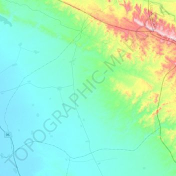
Nome: Mapa topográfico Northern Liravi RD, altitude, relevo.
Altitude média: 152 m
Altitude mínima: 2 m
Altitude máxima: 839 m
Outros mapas topográficos
Clique em um mapa para visualizar sua topografia, sua altitude e seu relevo.
Howmeh-ye Deylam RD
Iran > Bushehr Province > Deylam County
Howmeh-ye Deylam RD, Deylam Central District, Deylam County, Bushehr Province, Iran
Altitude média: 8 m