
Mapa topográfico Monte Rosa
Mapa interativo
Clique no mapa para exibir a altitude.
Sobre este mapa
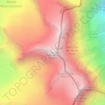
Nome: Mapa topográfico Monte Rosa, altitude, relevo.
Local: Monte Rosa, Zermatt, Visp, Wallis, 3920, Switzerland (45.93686 7.86670 45.93696 7.86680)
Altitude média: 4033 m
Altitude mínima: 3037 m
Altitude máxima: 4619 m
The peak is distinguished by the name Dufourspitze (in German, lit. Dufour Peak; French: Pointe Dufour, Italian: Punta Dufour). This replaced the former name Höchste Spitze (English: Highest Peak) that was indicated on the Swiss maps before the Federal Council, on January 28, 1863, decided to rename the mountain in honor of Guillaume-Henri Dufour. Dufour was a Swiss engineer, topographer, co-founder of the Red Cross and army general who led the Sonderbund campaign. This decision followed the completion of the Dufour Map, a series of military topographical maps created under the command of Dufour.
Outros mapas topográficos
Clique em um mapa para visualizar sua topografia, sua altitude e seu relevo.
Matterhorn
Switzerland > Wallis > Visp > Zermatt
Matterhorn, Zermatt, Visp, Wallis, 3920, Switzerland
Altitude média: 3295 m
Gornera
Switzerland > Wallis > Visp > Zermatt
Gornera, Zermatt, Visp, Wallis, 3920, Switzerland
Altitude média: 2226 m
Blatten
Switzerland > Wallis > Visp > Zermatt
Blatten, Zermatt, Visp, Wallis, 3920, Switzerland
Altitude média: 2149 m