
Mapa topográfico Los Alamos
Mapa interativo
Clique no mapa para exibir a altitude.
Sobre este mapa
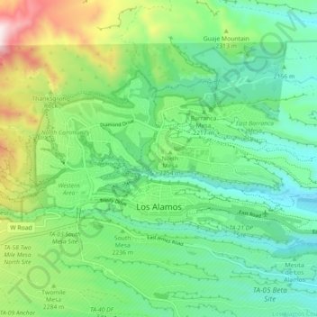
Nome: Mapa topográfico Los Alamos, altitude, relevo.
Altitude média: 2196 m
Altitude mínima: 1990 m
Altitude máxima: 2638 m
Los Alamos is located in northern New Mexico between the Rio Grande and the eastern rim of the Valles Caldera on the Pajarito Plateau, approximately 35 mi (56 km) to the northwest of Santa Fe. The elevation at the post office is 7,320 feet (2,230 m) and total land area is 11.14 square miles (28.9 km2).
Outros mapas topográficos
Clique em um mapa para visualizar sua topografia, sua altitude e seu relevo.
Los Alamos
United States > New Mexico > Los Alamos County > Los Alamos
Los Alamos, Los Alamos County, New Mexico, 87544, United States
Altitude média: 2196 m