
Mapa topográfico Ellenburg Depot
Mapa interativo
Clique no mapa para exibir a altitude.
Sobre este mapa
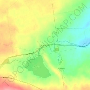
Nome: Mapa topográfico Ellenburg Depot, altitude, relevo.
Altitude média: 274 m
Altitude mínima: 226 m
Altitude máxima: 325 m
Outros mapas topográficos
Clique em um mapa para visualizar sua topografia, sua altitude e seu relevo.
Upper Chateaugay Lake Sandbar
United States > New York > Clinton County > Town of Ellenburg
Upper Chateaugay Lake Sandbar, Town of Ellenburg, Clinton County, New York, United States
Altitude média: 417 m
Merrill
United States > New York > Clinton County > Town of Ellenburg
Merrill, Town of Ellenburg, Clinton County, New York, 12955, United States
Altitude média: 424 m
Ellenburg Center
United States > New York > Clinton County > Town of Ellenburg
Ellenburg Center, Town of Ellenburg, Clinton County, New York, 12934, United States
Altitude média: 383 m
Harrigan
United States > New York > Clinton County > Town of Ellenburg
Harrigan, Town of Ellenburg, Clinton County, New York, 12933, United States
Altitude média: 508 m
Lake Roxanne
United States > New York > Clinton County > Town of Ellenburg > Ellenburg Depot
Lake Roxanne, Ellenburg Depot, Town of Ellenburg, Clinton County, New York, United States
Altitude média: 280 m