
Mapa topográfico Deer Horn Island
Mapa interativo
Clique no mapa para exibir a altitude.
Sobre este mapa
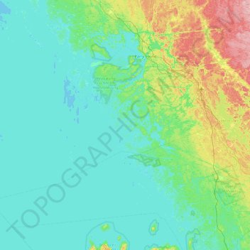
Nome: Mapa topográfico Deer Horn Island, altitude, relevo.
Altitude média: 199 m
Altitude mínima: 172 m
Altitude máxima: 328 m
Outros mapas topográficos
Clique em um mapa para visualizar sua topografia, sua altitude e seu relevo.
Pointe au Baril
Canada > Ontario > Parry Sound District > The Archipelago Township
Pointe au Baril, The Archipelago Township, Parry Sound District, Central Ontario, Ontario, Canada
Altitude média: 177 m
Conger Lake
Canada > Ontario > Parry Sound District > The Archipelago Township
Conger Lake, The Archipelago Township, Parry Sound District, Central Ontario, Ontario, Canada
Altitude média: 200 m
Moon River
Canada > Ontario > Parry Sound District > The Archipelago Township
Moon River, The Archipelago Township, Parry Sound District, Central Ontario, Ontario, Canada
Altitude média: 185 m
Moon River
Canada > Ontario > Parry Sound District > The Archipelago Township
Moon River, The Archipelago Township, Parry Sound District, Central Ontario, Ontario, Canada
Altitude média: 185 m
Watt Island
Canada > Ontario > Parry Sound District > The Archipelago Township
Watt Island, The Archipelago Township, Parry Sound District, Central Ontario, Ontario, Canada
Altitude média: 195 m