
Mapa topográfico Arkhyz
Mapa interativo
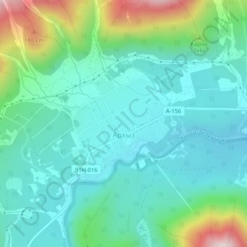
Clique no mapa para exibir a altitude.
Sobre este mapa
Nome: Mapa topográfico Arkhyz, altitude, relevo.
Altitude média: 1547 m
Altitude mínima: 1427 m
Altitude máxima: 1937 m
Arkhyz (also Nizhny Arkhyz Russian: Архыз; Karachay-Balkar: Ырхыз, Irxız; "mudflows") is a village in the valley of the Bolshoy Zelenchuk River, in the Republic of Karachay–Cherkessia, Greater Caucasus, Russia, about 70 km inland from the Black Sea shore. The modern village was founded in 1923 near the confluence of the Arkhyz and Pshish rivers. It is located in a mountainous region in the vicinity of the eponymous aul sitting at an altitude of 1,450 meters. The elevation of the surrounding mountains is more than 3,000 meters above the sea. The population is 505 (2010 Census).
Outros mapas topográficos
Clique em um mapa para visualizar sua topografia, sua altitude e seu relevo.
Архыз
Russia > Karachay-Cherkessia > Zelenchuksky District
Архыз, Архызское сельское поселение, Zelenchuksky District, Karachay-Cherkessia, North Caucasian Federal District, Russia
Altitude média: 2345 m