
Mapa topográfico Gemeinde Kössen
Mapa interativo
Clique no mapa para exibir a altitude.
Sobre este mapa
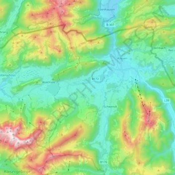
Nome: Mapa topográfico Gemeinde Kössen, altitude, relevo.
Local: Gemeinde Kössen, Bezirk Kitzbühel, Tyrol, 6345, Austria (47.59728 12.31908 47.69638 12.52534)
Altitude média: 979 m
Altitude mínima: 562 m
Altitude máxima: 1977 m
Kössen's topography lends itself to air sports in the summer months. The surrounding mountain massifs create great thermals, which are near-perfect for hang gliding and paragliding flights, whilst the valley-floor makes safe landing-grounds, as it is broad, flat and mostly meadow-land; furthermore, the winter ski-lifts allow equal access to the summits in their off-season, for the new market of air-sports adventurers.
Outros mapas topográficos
Clique em um mapa para visualizar sua topografia, sua altitude e seu relevo.
Scheffau
Austria > Bezirk Kitzbühel > Sankt Johann in Tirol
Scheffau, Sankt Johann in Tirol, Bezirk Kitzbühel, Austria
Altitude média: 939 m
Mittagskogel
Austria > Bezirk Kitzbühel > Jochberg
Mittagskogel, Jochberg, Bezirk Kitzbühel, Austria
Altitude média: 1838 m