
Mapa topográfico Lake Station
Mapa interativo
Clique no mapa para exibir a altitude.
Sobre este mapa
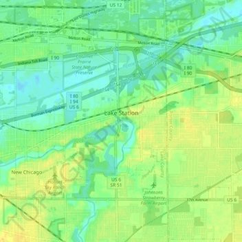
Nome: Mapa topográfico Lake Station, altitude, relevo.
Local: Lake Station, Lake County, Indiana, 46405, United States (41.55081 -87.31253 41.59456 -87.22170)
Altitude média: 189 m
Altitude mínima: 178 m
Altitude máxima: 203 m
Outros mapas topográficos
Clique em um mapa para visualizar sua topografia, sua altitude e seu relevo.
Center Township
United States > Indiana > Lake County
Center Township, Lake County, Indiana, 46307, United States
Altitude média: 220 m
Winfield Township
United States > Indiana > Lake County
Winfield Township, Lake County, Indiana, United States
Altitude média: 220 m
Lake Seven
United States > Indiana > Lake County > Crown Point
Lake Seven, Crown Point, Lake County, Indiana, United States
Altitude média: 220 m
Glen Park
United States > Indiana > Lake County > Gary
Glen Park, Gary, Lake County, Indiana, 46409, United States
Altitude média: 193 m
Miller
United States > Indiana > Lake County > Gary > Miller
Miller, Gary, Lake County, Indiana, 46403, United States
Altitude média: 186 m
Hammond
United States > Indiana > Lake County
Hammond, Lake County, Indiana, United States
Altitude média: 180 m
Munster
United States > Indiana > Lake County
Munster, Lake County, Indiana, 46321, United States
Altitude média: 187 m
Griffith
United States > Indiana > Lake County > Griffith
Griffith, Lake County, Indiana, 46319, United States
Altitude média: 190 m
Crown Point
United States > Indiana > Lake County > Crown Point
Crown Point, Lake County, Indiana, 46307, United States
Altitude média: 220 m
Gary
United States > Indiana > Lake County > Gary
Gary, Lake County, Indiana, United States
Altitude média: 185 m