
Mapa topográfico Melfi
Mapa interativo
Clique no mapa para exibir a altitude.
Sobre este mapa
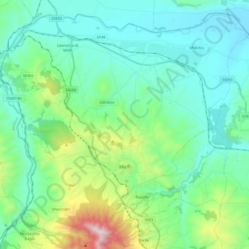
Nome: Mapa topográfico Melfi, altitude, relevo.
Local: Melfi, Potenza, Basilicata, 85025, Italy (40.94867 15.54287 41.10055 15.76704)
Altitude média: 377 m
Altitude mínima: 138 m
Altitude máxima: 1299 m
The Castle, dominates the whole town. It was probably constructed ex novo by the Normans (11th century), as no trace of pre-existing Byzantine or Lombard edifices has been found. Originally, it was probably a simple rectangle with square towers, with further towers defending the main gate. One of the main internal buildings was later (16th-18th centuries) turned into a baronial palace by enclosing the walls between the towers within new walls. Under the Angevine rule a new section was added on the slope descending to the Melfia stream, with several constructions rising at different altitudes. The Castle was chosen by King Charles II's wife, Mary of Hungary, as her residence. The Aragon kings gave it to the Caracciolo family, who rebuilt the side facing the city and dug a moat. Later it was a possession of the powerful House of Doria.
Outros mapas topográficos
Clique em um mapa para visualizar sua topografia, sua altitude e seu relevo.
Castelsaraceno
Italy > Basilicata > Potenza
Castelsaraceno, Potenza, Basilicata, Italy
Altitude média: 1104 m
Viadotto Pantanelle
Italy > Basilicata > Potenza > Nemoli
Viadotto Pantanelle, Nemoli, Potenza, Basilicata, Italy
Altitude média: 1685 m
Porco Morto
Italy > Basilicata > Potenza > Picerno > Porco Morto
Porco Morto, Picerno, Potenza, Basilicata, Italy
Altitude média: 1071 m
Balvano
Italy > Basilicata > Potenza > Balvano
Balvano, Potenza, Basilicata, Italy
Altitude média: 621 m