
Faça uma doação
Prepare-se para a sua próxima aventura:
Como Associado da Amazon, este site recebe uma comissão sobre compras elegíveis sem custo adicional para si.
Mapa topográfico Rafsanjan
Clique no mapa para exibir a altitude.
Faça uma doação
Prepare-se para a sua próxima aventura:
Como Associado da Amazon, este site recebe uma comissão sobre compras elegíveis sem custo adicional para si.
Rafsanjan
Rafsanjan is located in south part of the Lut desert, in north-west of Kerman province. The longitude of this city is 56 degrees east and the latitude is 30 degrees south. The Average distance between Kerman and this city is 110 km (68 mi). The city has an airport and railway (Tehran-Bandar Abbas route). Moreover, the altitude is 1,460 m (4,790 ft) and the land-measurement is approximately 10,687 km (6,641 mi). North part of Rafsanjan has a common frontier with Bafgh and Zarand; south part is neighboring with Bardsir and on west side with Anar and Shahre-Babak; finally east side of this beautiful city is neighboring with Kerman and Zarand. Rafsanjan has two seasonal rivers named as Shour and Giouderi. The mountains in the area are part of Zagros range, and Sarcheshmeh and Davaran are the most famous.
Faça uma doação
Prepare-se para a sua próxima aventura:
Como Associado da Amazon, este site recebe uma comissão sobre compras elegíveis sem custo adicional para si.
Sobre este mapa
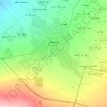
Nome: Mapa topográfico Rafsanjan, altitude, relevo.
Altitude média: 1539 m
Altitude mínima: 1477 m
Altitude máxima: 1653 m
Faça uma doação
Prepare-se para a sua próxima aventura:
Como Associado da Amazon, este site recebe uma comissão sobre compras elegíveis sem custo adicional para si.
Outros mapas topográficos
Clique em um mapa para visualizar sua topografia, sua altitude e seu relevo.