
Mapa topográfico Goldbach
Mapa interativo
Clique no mapa para exibir a altitude.
Sobre este mapa
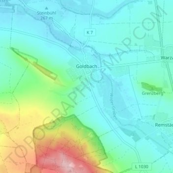
Nome: Mapa topográfico Goldbach, altitude, relevo.
Local: Goldbach, Nessetal, Landkreis Gotha, Thüringen, Deutschland (50.96677 10.62618 51.01018 10.67774)
Altitude média: 300 m
Altitude mínima: 259 m
Altitude máxima: 442 m
Outros mapas topográficos
Clique em um mapa para visualizar sua topografia, sua altitude e seu relevo.
Hochheim
Deutschland > Thüringen > Landkreis Gotha > Nessetal
Hochheim, Nessetal, Landkreis Gotha, Thüringen, Deutschland
Altitude média: 299 m
Ballstädt
Deutschland > Thüringen > Landkreis Gotha > Nessetal
Ballstädt, Nessetal, Landkreis Gotha, Thüringen, Deutschland
Altitude média: 287 m
Wangenheim
Deutschland > Thüringen > Landkreis Gotha > Nessetal
Wangenheim, Nessetal, Landkreis Gotha, Thüringen, Deutschland
Altitude média: 299 m