
Mapa topográfico Mount Davis
Mapa interativo
Clique no mapa para exibir a altitude.
Sobre este mapa
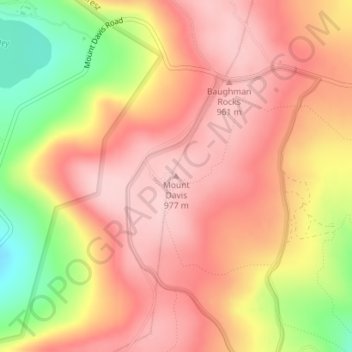
Nome: Mapa topográfico Mount Davis, altitude, relevo.
Altitude média: 908 m
Altitude mínima: 780 m
Altitude máxima: 975 m
Mount Davis has a humid continental climate that is affected by the high elevation significantly enough that the area feels slightly more like a cooler version of the climate zone during the winter months. Due to its high elevation, the area is colder much of the winter than Altoona, Johnstown, or State College, despite being well south of those locations. During the summer months, the area is a retreat for other Pennsylvanians with high temperatures averaging around 15 degrees cooler than Pittsburgh and eastern portions of the state. Mount Davis recorded many impressive record lows and is quite close to the state's all-time coldest temperature.
Outros mapas topográficos
Clique em um mapa para visualizar sua topografia, sua altitude e seu relevo.
Boynton
United States > Pennsylvania > Somerset County > Elk Lick Township > Boynton
Boynton, Elk Lick Township, Somerset County, Pennsylvania, 15532, United States
Altitude média: 656 m