
Mapa topográfico Dubuque County
Mapa interativo
Clique no mapa para exibir a altitude.
Sobre este mapa
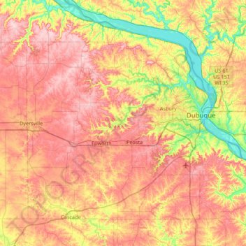
Nome: Mapa topográfico Dubuque County, altitude, relevo.
Local: Dubuque County, Iowa, United States (42.29334 -91.13344 42.67462 -90.47332)
Altitude média: 284 m
Altitude mínima: 180 m
Altitude máxima: 381 m
The county seat is Dubuque, Iowa, which is located along the Mississippi River in the east-central portion of the county. Eastern Dubuque County is markedly different from the western portion in that its topography is very uneven. The city of Dubuque and surrounding areas adjacent to the Mississippi River have many steep hills, bluffs, and ravines. Also, the eastern portion is more heavily wooded than the west, which is mostly rolling farmland.
Outros mapas topográficos
Clique em um mapa para visualizar sua topografia, sua altitude e seu relevo.
Dubuque
United States > Iowa > Dubuque County
Dubuque, Dubuque County, Iowa, United States
Altitude média: 241 m
Mississippi River
United States > Iowa > Dubuque County > Dubuque > Eagle Point
Mississippi River, Eagle Point, Dubuque, Dubuque County, Iowa, 52001, United States
Altitude média: 200 m
Mines of Spain State Recreation Area
United States > Iowa > Dubuque County > Dubuque
Mines of Spain State Recreation Area, Dubuque, Dubuque County, Iowa, United States
Altitude média: 217 m
Holy Cross
United States > Iowa > Dubuque County
Holy Cross, Dubuque County, Iowa, United States
Altitude média: 355 m
Farley
United States > Iowa > Dubuque County
Farley, Dubuque County, Iowa, 52046, United States
Altitude média: 335 m
Epworth
United States > Iowa > Dubuque County
Epworth, Dubuque County, Iowa, 52045, United States
Altitude média: 310 m