
Mapa topográfico Hemis Shukpachan
Mapa interativo
Clique no mapa para exibir a altitude.
Sobre este mapa
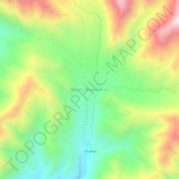
Nome: Mapa topográfico Hemis Shukpachan, altitude, relevo.
Local: Hemis Shukpachan, Khalsi tehsil, Leh District, Ladakh, India (34.29591 77.05741 34.33591 77.09741)
Altitude média: 3818 m
Altitude mínima: 3437 m
Altitude máxima: 4361 m
Outros mapas topográficos
Clique em um mapa para visualizar sua topografia, sua altitude e seu relevo.
Tingmosgang
India > Ladakh > Khalsi tehsil > Khaling
Tingmosgang, Khaling, Khalsi tehsil, Leh District, Ladakh, India
Altitude média: 3410 m