
Mapa topográfico Beaulieu
Mapa interativo
Clique no mapa para exibir a altitude.
Sobre este mapa
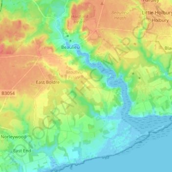
Nome: Mapa topográfico Beaulieu, altitude, relevo.
Altitude média: 19 m
Altitude mínima: -5 m
Altitude máxima: 46 m
Outros mapas topográficos
Clique em um mapa para visualizar sua topografia, sua altitude e seu relevo.
Brook
Vereinigtes Königreich > England > Hampshire > New Forest > Bramshaw
Brook, Bramshaw, New Forest, Hampshire, England, SO43 7HE, Vereinigtes Königreich
Altitude média: 65 m
St Leonards
Vereinigtes Königreich > England > Hampshire > New Forest
St Leonards, Beaulieu, New Forest, Hampshire, England, SO42 7XG, Vereinigtes Königreich
Altitude média: 8 m
Exbury
Vereinigtes Königreich > England > Hampshire > New Forest
Exbury, Exbury and Lepe, New Forest, Hampshire, England, SO45 1AH, Vereinigtes Königreich
Altitude média: 14 m
Brockenhurst
Vereinigtes Königreich > England > Hampshire > New Forest
Brockenhurst, New Forest, Hampshire, England, Vereinigtes Königreich
Altitude média: 39 m
East End
Vereinigtes Königreich > England > Hampshire > New Forest
East End, New Forest, Hampshire, England, SO41 5SY, Vereinigtes Königreich
Altitude média: 12 m