
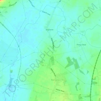
Mapa topográfico Rangeworthy
Mapa interativo
Clique no mapa para exibir a altitude.
Sobre este mapa
Nome: Mapa topográfico Rangeworthy, altitude, relevo.
Altitude média: 59 m
Altitude mínima: 48 m
Altitude máxima: 93 m
Outros mapas topográficos
Clique em um mapa para visualizar sua topografia, sua altitude e seu relevo.
Warmley
United Kingdom > England > South Gloucestershire
Warmley, Siston, South Gloucestershire, West of England, England, BS15 4PP, United Kingdom
Altitude média: 69 m
Marsh Common
United Kingdom > England > South Gloucestershire > Easter Compton
Marsh Common, Pilning and Severn Beach, Easter Compton, South Gloucestershire, West of England, England, BS35 4JU, United Kingdom
Altitude média: 10 m
Yate
United Kingdom > England > South Gloucestershire
Yate, South Gloucestershire, West of England, England, United Kingdom
Altitude média: 83 m
Siston
United Kingdom > England > South Gloucestershire
Siston, South Gloucestershire, West of England, England, United Kingdom
Altitude média: 80 m
Alveston
United Kingdom > England > South Gloucestershire
Alveston, South Gloucestershire, West of England, England, United Kingdom
Altitude média: 75 m
Kingswood
United Kingdom > England > South Gloucestershire
Kingswood, South Gloucestershire, West of England, England, BS15 8LQ, United Kingdom
Altitude média: 57 m