
Mapa topográfico Grenchen
Mapa interativo
Clique no mapa para exibir a altitude.
Sobre este mapa
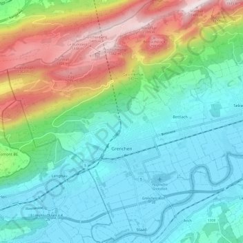
Nome: Mapa topográfico Grenchen, altitude, relevo.
Altitude média: 705 m
Altitude mínima: 424 m
Altitude máxima: 1411 m
The municipality is the capital of the Lebern District. It is the second largest city in the Canton of Solothurn. The municipality stretches from the hamlet of Staad along the Aare river, (at an elevation of 430 m (1,410 ft)) to the first mountain range of the Jura Mountains (the Oberer Grenchenberg is 1,348 m (4,423 ft)).