
Mapa topográfico Town of Fishkill
Mapa interativo
Clique no mapa para exibir a altitude.
Sobre este mapa
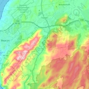
Nome: Mapa topográfico Town of Fishkill, altitude, relevo.
Local: Town of Fishkill, Dutchess County, New York, United States (41.43901 -74.00135 41.55952 -73.84264)
Altitude média: 178 m
Altitude mínima: -2 m
Altitude máxima: 479 m
According to the United States Census Bureau, the town has a total area of 32.0 square miles (82.9 km2), of which 27.3 square miles (70.8 km2) is land and 4.7 square miles (12.1 km2), or 14.55%, is water. The elevation of the town varies from sea level along the Hudson River (Fishkill Waterfront, Fishkill Landing, Dutchess Junction) to 1,600 feet (490 m) above sea level (South Beacon Mountain).
Outros mapas topográficos
Clique em um mapa para visualizar sua topografia, sua altitude e seu relevo.
City of Poughkeepsie
United States > New York > Dutchess County
City of Poughkeepsie, Dutchess County, New York, 12601, United States
Altitude média: 49 m
Hopewell Junction
United States > New York > Dutchess County > Town of East Fishkill
Hopewell Junction, Town of East Fishkill, Dutchess County, New York, United States
Altitude média: 83 m
Rhinecliff
United States > New York > Dutchess County > Town of Rhinebeck
Rhinecliff, Town of Rhinebeck, Dutchess County, New York, 12574, United States
Altitude média: 19 m
Town of La Grange
United States > New York > Dutchess County
Town of La Grange, Dutchess County, New York, 12540, United States
Altitude média: 118 m
Town of Hyde Park
United States > New York > Dutchess County
Town of Hyde Park, Dutchess County, New York, United States
Altitude média: 93 m
Town of Washington
United States > New York > Dutchess County
Town of Washington, Dutchess County, New York, 12545, United States
Altitude média: 225 m
Village of Millerton
United States > New York > Dutchess County
Village of Millerton, Town of North East, Dutchess County, New York, United States
Altitude média: 243 m
Staatsburg
United States > New York > Dutchess County > Town of Hyde Park
Staatsburg, Town of Hyde Park, Dutchess County, New York, United States
Altitude média: 25 m
Town of North East
United States > New York > Dutchess County
Town of North East, Dutchess County, New York, 12546, United States
Altitude média: 267 m
Town of Pleasant Valley
United States > New York > Dutchess County
Town of Pleasant Valley, Dutchess County, New York, United States
Altitude média: 112 m
Village of Fishkill
United States > New York > Dutchess County
Village of Fishkill, Town of Fishkill, Dutchess County, New York, 12524, United States
Altitude média: 75 m
Glenham
United States > New York > Dutchess County > Town of Fishkill
Glenham, Town of Fishkill, Dutchess County, New York, 12527, United States
Altitude média: 108 m
State Line
United States > New York > Dutchess County > State Line
State Line, Town of North East, Dutchess County, New York, 12546, United States
Altitude média: 268 m
Beacon
United States > New York > Dutchess County > Beacon > Beacon
Beacon, Dutchess County, New York, 12508, United States
Altitude média: 91 m
Town of Red Hook
United States > New York > Dutchess County > Town of Red Hook
Town of Red Hook, Dutchess County, New York, United States
Altitude média: 62 m
Stanfordville
United States > New York > Dutchess County
Stanfordville, Town of Stanford, Dutchess County, New York, 12506, United States
Altitude média: 137 m
Pine Plains CDP
United States > New York > Dutchess County
Pine Plains CDP, Dutchess County, New York, 12567, United States
Altitude média: 149 m
City of Beacon
United States > New York > Dutchess County
City of Beacon, Dutchess County, New York, 12508, United States
Altitude média: 68 m
Hurd Corners
United States > New York > Dutchess County > Town of Pawling
Hurd Corners, Town of Pawling, Dutchess County, New York, 12564, United States
Altitude média: 199 m
Village of Millbrook
United States > New York > Dutchess County
Village of Millbrook, Town of Washington, Dutchess County, New York, 12545, United States
Altitude média: 196 m