
Mapa topográfico Maghera
Mapa interativo
Clique no mapa para exibir a altitude.
Sobre este mapa
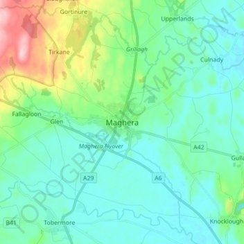
Nome: Mapa topográfico Maghera, altitude, relevo.
Altitude média: 72 m
Altitude mínima: 32 m
Altitude máxima: 223 m
Outros mapas topográficos
Clique em um mapa para visualizar sua topografia, sua altitude e seu relevo.
Mullaghmore
Royaume-Uni > Irlande du Nord > County Londonderry
Mullaghmore, County Londonderry, Ulster, Irlande du Nord, BT45 7DZ, Royaume-Uni
Altitude média: 390 m
Magherafelt
Royaume-Uni > Irlande du Nord > County Londonderry
Magherafelt, County Londonderry, Ulster, Irlande du Nord, BT45 6EE, Royaume-Uni
Altitude média: 59 m
Londonderry/Derry
Royaume-Uni > Irlande du Nord > County Londonderry
Londonderry/Derry, County Borough of Londonderry, County Londonderry, Irlande du Nord, BT48 6BU, Royaume-Uni
Altitude média: 88 m