
Mapa topográfico Manarcadu
Mapa interativo
Clique no mapa para exibir a altitude.
Sobre este mapa
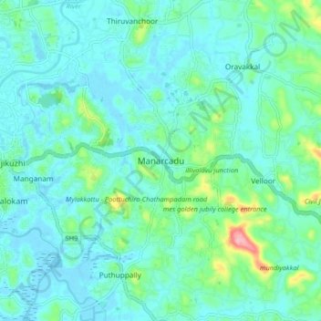
Nome: Mapa topográfico Manarcadu, altitude, relevo.
Local: Manarcadu, Kottayam, Kottayam District, Kerala, 686019, India (9.54778 76.54227 9.62778 76.62227)
Altitude média: 23 m
Altitude mínima: -2 m
Altitude máxima: 129 m
Outros mapas topográficos
Clique em um mapa para visualizar sua topografia, sua altitude e seu relevo.
Meenachil
India > Kerala > Kottayam > Pulikuttisseri
Meenachil, Pulikuttisseri, Kottayam, Kottayam District, Kerala, India
Altitude média: 6 m
Paruthumpara
Paruthumpara, Kottayam, Kottayam District, Kerala, 686533, India
Altitude média: 16 m
Puthuppally
Puthuppally, Kottayam, Kerala, 686011, India
Altitude média: 18 m
Thiruvanchoor
India > Kerala > Kottayam > Thiruvanchoor
Thiruvanchoor, Kottayam, Kerala, 686637, India
Altitude média: 11 m
Karappuzha Temple Kulam
India > Kerala > Kottayam > Kottayam
Karappuzha Temple Kulam, Kottayam, Kerala, India
Altitude média: 6 m
Mattakkara
India > Kerala > Kottayam > Mattakkara
Mattakkara, Kottayam, Kerala, 686564, India
Altitude média: 41 m