
Mapa topográfico Franz Josef Glacier
Mapa interativo
Clique no mapa para exibir a altitude.
Sobre este mapa
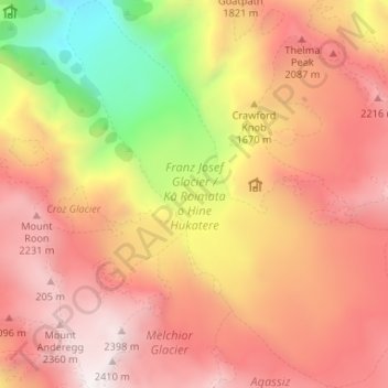
Nome: Mapa topográfico Franz Josef Glacier, altitude, relevo.
Altitude média: 1709 m
Altitude mínima: 578 m
Altitude máxima: 2451 m
The névé or snowfield at the head of Franz Josef Glacier is over 2,500 metres (8,200 ft) above sea level and 20 square kilometres (7.7 sq mi) in area. This wide névé, which is over 300 metres (980 ft) deep, feeds large amounts of compacted snow into a steep and narrow valley which drops quickly to very low altitudes: the glacier descends to 300 metres (980 ft) above sea level in just 11 km (6.8 mi). This combination of factors leads to Franz Josef persisting where most temperate-zone glaciers would have already melted, and allows it to share a valley with temperate rain forest.
Outros mapas topográficos
Clique em um mapa para visualizar sua topografia, sua altitude e seu relevo.
Mount Howitt
New Zealand > West Coast > Westland District
Mount Howitt, Westland District, West Coast, New Zealand
Altitude média: 1577 m
Hokitika
New Zealand > West Coast > Westland District
Hokitika, Westland District, West Coast, 7810, New Zealand
Altitude média: 14 m
Perth River
New Zealand > West Coast > Westland District
Perth River, Westland District, West Coast, New Zealand
Altitude média: 918 m
Storm
New Zealand > West Coast > Westland District
Storm, Westland District, West Coast, New Zealand
Altitude média: 1525 m
Ōkārito
New Zealand > West Coast > Westland District > Ōkārito
Ōkārito, Westland District, West Coast, New Zealand
Altitude média: 25 m