
Mapa topográfico Bolinas
Mapa interativo
Clique no mapa para exibir a altitude.
Sobre este mapa
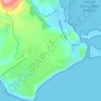
Nome: Mapa topográfico Bolinas, altitude, relevo.
Altitude média: 28 m
Altitude mínima: -1 m
Altitude máxima: 149 m
Bolinas sits at an elevation of 36 feet (11 m) above sea level. It is bound on the northeast by Bolinas Lagoon and Kent Island and on the south by Bolinas Bay and Duxbury Point. According to the United States Census Bureau, the CDP has a total area of 5.8 square miles (15 km2), all of it land. The GNIS has cited archaic alternate town-names, including "Ballenas", "Baulenas", "Baulings", and "Bawlines".