
Mapa topográfico Porrentruy
Mapa interativo
Clique no mapa para exibir a altitude.
Sobre este mapa
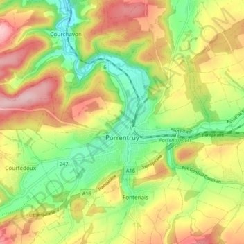
Nome: Mapa topográfico Porrentruy, altitude, relevo.
Local: Porrentruy, District de Porrentruy, Jura, 2900, Switzerland (47.40041 7.02424 47.44083 7.10658)
Altitude média: 486 m
Altitude mínima: 397 m
Altitude máxima: 584 m
The municipality lies on the first stretch of the motorway (A16 or E27) to open (in 1998) in the canton of Jura between Delémont and Belfort, France. The motorway is meant to be completed in 2016, the difficult topography of the Jura only allowing the opening of short sections, one by one. This explains why the international railway played such an important role in the economic rise of Porrentruy because the railway follows the course of the Allaine river to the economic rail hub at Belfort.