

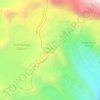
Mapa topográfico Sitapur
Clique no mapa para exibir a altitude.
Sobre este mapa

Nome: Mapa topográfico Sitapur, altitude, relevo.
Local: Sitapur, Ukhimath, Rudraprayag, Uttarakhand, 246471, India (30.59714 78.97867 30.63714 79.01867)
Altitude média: 2062 m
Altitude mínima: 1506 m
Altitude máxima: 2856 m
Outros mapas topográficos
Clique em um mapa para visualizar sua topografia, sua altitude e seu relevo.


Kedarnath Wildlife Sanctuary
India > Uttarakhand > Ukhimath
Located in the Himalayan Highlands with an elevation ranging from 1,160 metres (3,810 ft) (near Phata) to the Chaukhamba peak at 7,068 m (23,189 ft), it was a notified reserve forest between 1916 and 1920. It was changed to a sanctuary on 21 January 1972, and has been designated a "Habitat/Species Management…
Altitude média: 3285 m