
Mapa topográfico River Nith
Clique no mapa para exibir a altitude.
Sobre este mapa
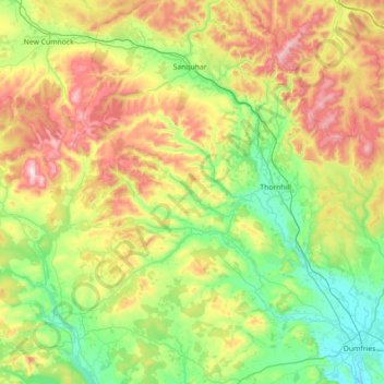
Nome: Mapa topográfico River Nith, altitude, relevo.
Local: River Nith, Dumfries and Galloway, Scotland, United Kingdom (54.97786 -4.31062 55.40158 -3.56998)
Altitude média: 231 m
Altitude mínima: 0 m
Altitude máxima: 791 m
Outros mapas topográficos
Clique em um mapa para visualizar sua topografia, sua altitude e seu relevo.
Garden of Cosmic Speculation
United Kingdom > Scotland > Dumfries and Galloway > Burnhead
Altitude média: 31 m
Eskdalemuir
United Kingdom > Scotland > Dumfries and Galloway
In spite of it being located inland, the dull and wet nature of the climate due to the elevation leads to chilly summers that are colder than more northerly locations such as Glasgow and Edinburgh. The inland nature of the climate is more manifest during winter months with frosts being common, and the average…
Altitude média: 246 m
Merrick
United Kingdom > Scotland > Dumfries and Galloway
The Merrick, or simply Merrick (Scottish Gaelic: A' Mhearag), is a mountain in the Range of the Awful Hand, a sub-range of the Galloway Hills range, part of the Southern Uplands of Scotland. The summit elevation is 843 metres (2,766 feet), making it the highest mountain in the Southern Uplands and southern…
Altitude média: 591 m