
Mapa topográfico Osterode
Mapa interativo
Clique no mapa para exibir a altitude.
Sobre este mapa
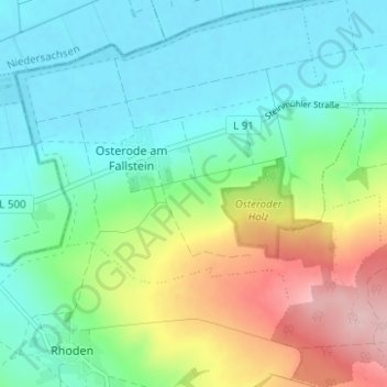
Nome: Mapa topográfico Osterode, altitude, relevo.
Altitude média: 141 m
Altitude mínima: 83 m
Altitude máxima: 278 m
Outros mapas topográficos
Clique em um mapa para visualizar sua topografia, sua altitude e seu relevo.
Hoppenstedt
Deutschland > Sachsen-Anhalt > Landkreis Harz > Osterwieck
Hoppenstedt, Osterwieck, Landkreis Harz, Sachsen-Anhalt, 38835, Deutschland
Altitude média: 128 m
Rhoden
Deutschland > Sachsen-Anhalt > Landkreis Harz > Osterwieck
Rhoden, Osterwieck, Landkreis Harz, Sachsen-Anhalt, Deutschland
Altitude média: 156 m