
Mapa topográfico Lysaghtstown
Mapa interativo
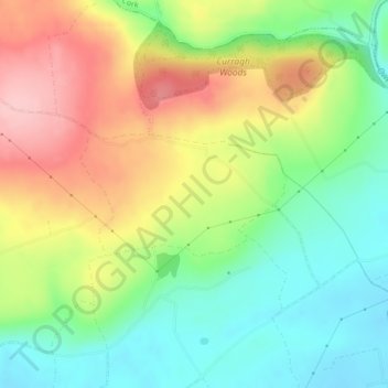
Clique no mapa para exibir a altitude.
Sobre este mapa
Nome: Mapa topográfico Lysaghtstown, altitude, relevo.
Altitude média: 81 m
Altitude mínima: 14 m
Altitude máxima: 169 m
Outros mapas topográficos
Clique em um mapa para visualizar sua topografia, sua altitude e seu relevo.
Coosane
Ireland > County Cork > Municipal District of Cobh
Coosane, Watergrasshill, Municipal District of Cobh, County Cork, Munster, Ireland
Altitude média: 108 m
Tullagreen
Ireland > County Cork > Municipal District of Cobh
Tullagreen, Carrigtohill ED, Municipal District of Cobh, County Cork, Munster, Ireland
Altitude média: 12 m
Ballynabortagh
Ireland > County Cork > Municipal District of Cobh
Ballynabortagh, Killeagh, Municipal District of Cobh, County Cork, Munster, Ireland
Altitude média: 153 m
Ballynanelagh
Ireland > County Cork > Municipal District of Cobh > Knockraha
Ballynanelagh, Knockraha, Municipal District of Cobh, County Cork, Munster, Ireland
Altitude média: 113 m