
Mapa topográfico Heidingsfeld
Mapa interativo
Clique no mapa para exibir a altitude.
Sobre este mapa
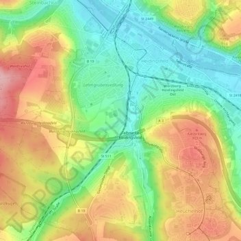
Nome: Mapa topográfico Heidingsfeld, altitude, relevo.
Local: Heidingsfeld, Würzburg, Bayern, Deutschland (49.73848 9.92658 49.77142 9.98539)
Altitude média: 244 m
Altitude mínima: 170 m
Altitude máxima: 333 m
Outros mapas topográficos
Clique em um mapa para visualizar sua topografia, sua altitude e seu relevo.
Würzburg
Deutschland > Bayern > Würzburg
Würzburg, Unterfranken, Bayern, 97070, Deutschland
Altitude média: 281 m
Kapitelshöfe
Deutschland > Bayern > Würzburg
Kapitelshöfe, Würzburg Altstadt, Würzburg, Bayern, 97070, Deutschland
Altitude média: 224 m
Zellerau
Deutschland > Bayern > Würzburg
Zellerau, Würzburg, Bayern, 97082, Deutschland
Altitude média: 222 m
Würzburg Altstadt
Deutschland > Bayern > Würzburg
Würzburg Altstadt, Würzburg, Unterfranken, Bayern, 97070, Deutschland
Altitude média: 204 m
Grünbrücke Guttenberger Forst
Deutschland > Bayern > Würzburg
Grünbrücke Guttenberger Forst, Steinbachtal, Würzburg, Bayern, 97082, Deutschland
Altitude média: 318 m
Lengfeld
Deutschland > Bayern > Würzburg
Lengfeld, Würzburg, Bayern, 97076, Deutschland
Altitude média: 237 m
Steinbachtal
Deutschland > Bayern > Würzburg
Steinbachtal, Würzburg, Bayern, 97082, Deutschland
Altitude média: 262 m
Rottenbauer
Deutschland > Bayern > Würzburg
Rottenbauer, Würzburg, Bayern, Deutschland
Altitude média: 267 m
Lindleinsmühle
Deutschland > Bayern > Würzburg
Lindleinsmühle, Würzburg, Unterfranken, Bayern, 97078, Deutschland
Altitude média: 230 m
Sanderau
Deutschland > Bayern > Würzburg
Sanderau, Würzburg, Unterfranken, Bayern, 97072, Deutschland
Altitude média: 214 m