
Mapa topográfico Challapalli
Mapa interativo
Clique no mapa para exibir a altitude.
Sobre este mapa
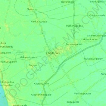
Nome: Mapa topográfico Challapalli, altitude, relevo.
Altitude média: 8 m
Altitude mínima: 1 m
Altitude máxima: 13 m
Challapalli is located at 16°07′00″N 80°56′00″E / 16.1167°N 80.9333°E / 16.1167; 80.9333. It has an average elevation of 7 metres (23 ft). It is located 25 kilometres (16 mi) from the district headquarters, Machilipatnam, and lies on the border of the Krishna District and the Guntur District near Repalle, in the South Guntur District.
Outros mapas topográficos
Clique em um mapa para visualizar sua topografia, sua altitude e seu relevo.
Ramanagaram
India > Andhra Pradesh > Challapalle
Ramanagaram, Challapalle, Krishna District, Andhra Pradesh, 521126, India
Altitude média: 8 m