
Mapa topográfico Sullivan County
Mapa interativo
Clique no mapa para exibir a altitude.
Sobre este mapa
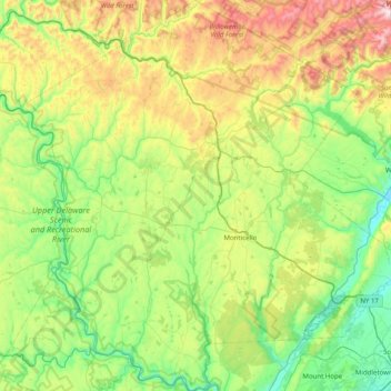
Nome: Mapa topográfico Sullivan County, altitude, relevo.
Local: Sullivan County, New York, USA (41.42166 -75.14682 42.01638 -74.36433)
Altitude média: 435 m
Altitude mínima: 98 m
Altitude máxima: 1259 m
Outros mapas topográficos
Clique em um mapa para visualizar sua topografia, sua altitude e seu relevo.
Chinatown
USA > New York > New York City
Chinatown, Manhattan, Manhattan Community Board 2, New York County, New York City, New York, USA
Altitude média: 12 m
Bramanville
USA > New York > Bramanville
Bramanville, Town of Cobleskill, Schoharie County, New York, 12092, USA
Altitude média: 320 m
Little Britain
USA > New York > Little Britain
Little Britain, Town of New Windsor, Orange County, New York, 12575, USA
Altitude média: 140 m
Avalanche Lake
Avalanche Lake, Avalanche Pass Trail, Essex County, New York, USA
Altitude média: 1066 m
Mount Warren
Mount Warren, Town of Bovina, Delaware County, New York, USA
Altitude média: 677 m
New Windsor
USA > New York > New Windsor
New Windsor, Town of New Windsor, Orange County, New York, USA
Altitude média: 39 m
Sawtooth Mountains
Sawtooth Mountains, Franklin County, New York, USA
Altitude média: 927 m
Big Bear Mountain
Big Bear Mountain, Town of Johnsburg, Warren County, New York, USA
Altitude média: 616 m
Roosevelt Island
USA > New York > New York City
Roosevelt Island, Manhattan Community Board 8, New York County, New York City, New York, 10044, USA
Altitude média: 13 m
Livingston Island
Livingston Island, Town of Philipstown, Putnam County, New York, 10922, USA
Altitude média: 156 m
Flat Top Mountain
Flat Top Mountain, Franklin County, New York, USA
Altitude média: 568 m