
Mapa topográfico Oberhaid
Mapa interativo
Clique no mapa para exibir a altitude.
Sobre este mapa
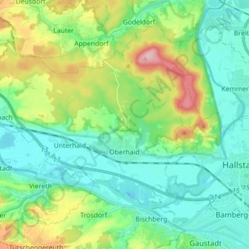
Nome: Mapa topográfico Oberhaid, altitude, relevo.
Local: Oberhaid, Landkreis Bamberg, Bayern, 96173, Deutschland (49.91477 10.72112 49.96892 10.84614)
Altitude média: 275 m
Altitude mínima: 225 m
Altitude máxima: 407 m
Outros mapas topográficos
Clique em um mapa para visualizar sua topografia, sua altitude e seu relevo.
Frensdorf
Deutschland > Bayern > Landkreis Bamberg
Frensdorf, Landkreis Bamberg, Bayern, 96158, Deutschland
Altitude média: 286 m
Viereth-Trunstadt
Deutschland > Bayern > Landkreis Bamberg
Viereth-Trunstadt, Landkreis Bamberg, Bayern, 96191, Deutschland
Altitude média: 288 m