Mapa topográfico Cullingworth
Clique no mapa para exibir a altitude.
Sobre este mapa
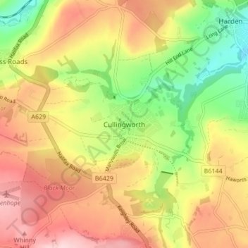
Nome: Mapa topográfico Cullingworth, altitude, relevo.
Altitude média: 239 m
Altitude mínima: 117 m
Altitude máxima: 352 m

Clique no mapa para exibir a altitude.
Nome: Mapa topográfico Cullingworth, altitude, relevo.
Altitude média: 239 m
Altitude mínima: 117 m
Altitude máxima: 352 m
Como Associado da Amazon, este site recebe uma comissão sobre compras elegíveis sem custo adicional para si.