
Mapa topográfico Freedom Island
Mapa interativo
Clique no mapa para exibir a altitude.
Sobre este mapa
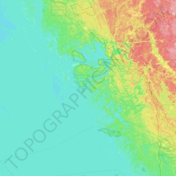
Nome: Mapa topográfico Freedom Island, altitude, relevo.
Altitude média: 201 m
Altitude mínima: 171 m
Altitude máxima: 327 m
Outros mapas topográficos
Clique em um mapa para visualizar sua topografia, sua altitude e seu relevo.
Mayne Island
Canada > Ontario > The Archipelago
Mayne Island, The Archipelago, Parry Sound District, Ontario, Canada
Altitude média: 194 m
Isabel Island
Canada > Ontario > The Archipelago
Isabel Island, The Archipelago, Parry Sound District, Ontario, Canada
Altitude média: 198 m
Range Island
Canada > Ontario > The Archipelago
Range Island, The Archipelago, Parry Sound District, Ontario, Canada
Altitude média: 196 m
Gay Island
Canada > Ontario > The Archipelago
Gay Island, The Archipelago, Parry Sound District, Ontario, Canada
Altitude média: 196 m