
Mapa topográfico Johnson City
Mapa interativo
Clique no mapa para exibir a altitude.
Sobre este mapa
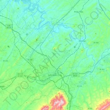
Nome: Mapa topográfico Johnson City, altitude, relevo.
Altitude média: 513 m
Altitude mínima: 399 m
Altitude máxima: 975 m
The steep mountains, rolling hills, and valleys surrounding the region are part of the Appalachian Ridge-and-Valley Province, and Johnson City is just west of the Blue Ridge Mountains. Roan Mountain, with an elevation of over 6,000 feet (1,800 m), is approximately 20 miles (32 km) to the southeast of the city. Buffalo Mountain, a ridge over 2,700 feet (820 m) high, is the location of a city park on the south side of town. The Watauga River arm of Boone Lake, a Tennessee Valley Authority reservoir, is partly within the city limits. The Nolichucky River flows 12 miles (19 km) to the south of Johnson City. Whitewater rafting and kayaking opportunities exist 20 miles (32 km) south of Johnson City where that river flows from the North Carolina state line near Erwin.
Outros mapas topográficos
Clique em um mapa para visualizar sua topografia, sua altitude e seu relevo.
Fall Branch
United States > Tennessee > Washington County
Fall Branch, Washington County, East Tennessee, Tennessee, United States
Altitude média: 487 m
Dogwood Acres
United States > Tennessee > Washington County > Johnson City
Dogwood Acres, Johnson City, Washington County, East Tennessee, Tennessee, 37684, United States
Altitude média: 550 m
El Rancho
United States > Tennessee > Washington County > Johnson City
El Rancho, Johnson City, Washington County, East Tennessee, Tennessee, United States
Altitude média: 469 m
Jonesborough
United States > Tennessee > Washington County
Jonesborough, Washington County, East Tennessee, Tennessee, 37659, United States
Altitude média: 543 m
Buffalo Mountain
United States > Tennessee > Washington County
Buffalo Mountain, Washington County, Tennessee, 37684, United States
Altitude média: 780 m
East Ridge
United States > Tennessee > Washington County > Johnson City > East Ridge
East Ridge, Johnson City, Washington County, Tennessee, 37601, United States
Altitude média: 509 m
Carnegie
United States > Tennessee > Washington County > Johnson City > Carnegie
Carnegie, Johnson City, Washington County, Tennessee, 37601, United States
Altitude média: 505 m
Johnson City
United States > Tennessee > Washington County > Johnson City
Johnson City, Washington County, Tennessee, 37614, United States
Altitude média: 583 m