
Faça uma doação
Prepare-se para a sua próxima aventura:
Como Associado da Amazon, este site recebe uma comissão sobre compras elegíveis sem custo adicional para si.
Mapa topográfico Burnaby
Clique no mapa para exibir a altitude.
Faça uma doação
Prepare-se para a sua próxima aventura:
Como Associado da Amazon, este site recebe uma comissão sobre compras elegíveis sem custo adicional para si.
Burnaby
Burnaby occupies 98.60 square kilometres (38.07 sq mi) and is located at the geographic centre of the Metro Vancouver area and home to the Metro Vancouver regional government in Metrotown. Situated between the city of Vancouver on the west and Port Moody, Coquitlam, and New Westminster on the east, Burnaby is bounded by Burrard Inlet and the Fraser River on the north and south, respectively. Burnaby, Vancouver and New Westminster collectively occupy the major portion of the Burrard Peninsula. The elevation of Burnaby ranges from sea level to a maximum of 370 metres (1,210 ft) atop Burnaby Mountain. Due to its elevation, the city of Burnaby typically has quite a bit more snowfall during the winter months than nearby Vancouver or Richmond. Overall, the physical landscape of Burnaby is one of hills, ridges, valleys and an alluvial plain. The land features and their relative locations have had an influence on the location, type and form of development in the city.
Faça uma doação
Prepare-se para a sua próxima aventura:
Como Associado da Amazon, este site recebe uma comissão sobre compras elegíveis sem custo adicional para si.
Sobre este mapa
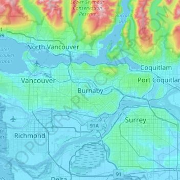
Nome: Mapa topográfico Burnaby, altitude, relevo.
Altitude média: 144 m
Altitude mínima: -4 m
Altitude máxima: 1429 m
Faça uma doação
Prepare-se para a sua próxima aventura:
Como Associado da Amazon, este site recebe uma comissão sobre compras elegíveis sem custo adicional para si.
Outros mapas topográficos
Clique em um mapa para visualizar sua topografia, sua altitude e seu relevo.
Deer Lake Park
Canada > British Columbia > Metro Vancouver Regional District > Burnaby
Altitude média: 64 m
Burnaby Lake
Canada > British Columbia > Metro Vancouver Regional District > Burnaby
Altitude média: 32 m
Central Park
Canada > British Columbia > Metro Vancouver Regional District > Burnaby
Altitude média: 113 m
Brentwood
Canada > British Columbia > Metro Vancouver Regional District > Burnaby
Altitude média: 69 m
Faça uma doação
Prepare-se para a sua próxima aventura:
Como Associado da Amazon, este site recebe uma comissão sobre compras elegíveis sem custo adicional para si.
Stride Hill
Canada > British Columbia > Metro Vancouver Regional District > Burnaby
Altitude média: 68 m
Riverway Sports Complex
Canada > British Columbia > Metro Vancouver Regional District > Burnaby
Altitude média: 42 m
Deer Lake
Canada > British Columbia > Metro Vancouver Regional District > Burnaby
Altitude média: 60 m
Faça uma doação
Prepare-se para a sua próxima aventura:
Como Associado da Amazon, este site recebe uma comissão sobre compras elegíveis sem custo adicional para si.
Burnaby Lake Regional Park
Canada > British Columbia > Metro Vancouver Regional District > Burnaby
Altitude média: 51 m
Government Road
Canada > British Columbia > Metro Vancouver Regional District > Burnaby
Altitude média: 45 m
Stoney Creek Park
Canada > British Columbia > Metro Vancouver Regional District > Burnaby
Altitude média: 85 m
Barnet Marine Park
Canada > British Columbia > Metro Vancouver Regional District > Burnaby
Altitude média: 95 m
Faça uma doação
Prepare-se para a sua próxima aventura:
Como Associado da Amazon, este site recebe uma comissão sobre compras elegíveis sem custo adicional para si.