
Mapa topográfico Holderness
Mapa interativo
Clique no mapa para exibir a altitude.
Sobre este mapa
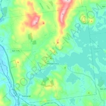
Nome: Mapa topográfico Holderness, altitude, relevo.
Altitude média: 252 m
Altitude mínima: 138 m
Altitude máxima: 657 m
According to the United States Census Bureau, the town has a total area of 35.7 square miles (92.5 km2), of which 30.3 square miles (78.6 km2) are land and 5.4 square miles (13.9 km2) are water, comprising 15.05% of the town. Bounded on the northwest by the Pemigewasset River, Holderness is drained by Owl Brook and the Squam River. Part of Squam Lake is in the east, and Little Squam Lake is in the center. Mount Prospect, with an elevation of 2,064 feet (629 m) above sea level, is in the north. The highest point in Holderness is Mount Webster in the northeast part of the town, elevation 2,076 feet (633 m) and part of the Squam Range. Via the Pemigewasset River, Holderness lies fully within the Merrimack River watershed.
Outros mapas topográficos
Clique em um mapa para visualizar sua topografia, sua altitude e seu relevo.
East Hebron
United States > New Hampshire > Grafton County > Hebron
East Hebron, Hebron, Grafton County, New Hampshire, 03241, United States
Altitude média: 268 m
Montcalm
United States > New Hampshire > Grafton County
Montcalm, Grafton County, New Hampshire, 03748, United States
Altitude média: 436 m
Ashland
United States > New Hampshire > Grafton County
Ashland, Grafton County, New Hampshire, 03217, United States
Altitude média: 231 m
Easton
United States > New Hampshire > Grafton County
Easton, Grafton County, New Hampshire, United States
Altitude média: 586 m
Lyme Center
United States > New Hampshire > Grafton County > Lyme
Lyme Center, Lyme, Grafton County, New Hampshire, 03769, United States
Altitude média: 336 m
Pike
United States > New Hampshire > Grafton County > Haverhill
Pike, Haverhill, Grafton County, New Hampshire, 03765, United States
Altitude média: 287 m
Stinson Lake
United States > New Hampshire > Grafton County > Rumney > Stinson Lake
Stinson Lake, Rumney, Grafton County, New Hampshire, United States
Altitude média: 460 m
West Lebanon
United States > New Hampshire > Grafton County > Lebanon
West Lebanon, Lebanon, Grafton County, New Hampshire, 03784, United States
Altitude média: 165 m
Benton
United States > New Hampshire > Grafton County
Benton, Grafton County, New Hampshire, United States
Altitude média: 558 m
Bridgewater
United States > New Hampshire > Grafton County
Bridgewater, Grafton County, New Hampshire, United States
Altitude média: 302 m
Monroe
United States > New Hampshire > Grafton County
Monroe, Grafton County, New Hampshire, 03771, United States
Altitude média: 320 m
North Woodstock
United States > New Hampshire > Grafton County > Woodstock
North Woodstock, Woodstock, Grafton County, New Hampshire, 03262, United States
Altitude média: 306 m
Woodsville
United States > New Hampshire > Grafton County > Haverhill
Woodsville, Haverhill, Grafton County, New Hampshire, 05081, United States
Altitude média: 195 m
Enfield Center
United States > New Hampshire > Grafton County > Enfield
Enfield Center, Enfield, Grafton County, New Hampshire, 03749, United States
Altitude média: 357 m
Glencliff
United States > New Hampshire > Grafton County > Warren
Glencliff, Warren, Grafton County, New Hampshire, 03238, United States
Altitude média: 410 m
Jewell Hill
United States > New Hampshire > Grafton County > Groton
Jewell Hill, Groton, Grafton County, New Hampshire, United States
Altitude média: 466 m
Boutin Corner
United States > New Hampshire > Grafton County > Benton
Boutin Corner, Benton, Grafton County, New Hampshire, United States
Altitude média: 446 m
Russel Pond
United States > New Hampshire > Grafton County > Woodstock
Russel Pond, Woodstock, Grafton County, New Hampshire, United States
Altitude média: 513 m
Bristol
United States > New Hampshire > Grafton County
Bristol, Grafton County, New Hampshire, 03222, United States
Altitude média: 254 m
Bethlehem
United States > New Hampshire > Grafton County
Bethlehem, Grafton County, New Hampshire, 03574, United States
Altitude média: 528 m
Pine Knob
United States > New Hampshire > Grafton County > Bethlehem
Pine Knob, Bethlehem, Grafton County, New Hampshire, United States
Altitude média: 413 m
Mount Pemigewasset
United States > New Hampshire > Grafton County > Lincoln
Mount Pemigewasset, Lincoln, Grafton County, New Hampshire, United States
Altitude média: 608 m
Campton Lower Village
United States > New Hampshire > Grafton County > Campton
Campton Lower Village, Campton, Grafton County, New Hampshire, 03223, United States
Altitude média: 260 m
Parker Hill
United States > New Hampshire > Grafton County > Lyman
Parker Hill, Lyman, Grafton County, New Hampshire, United States
Altitude média: 350 m
Cheever
United States > New Hampshire > Grafton County > Dorchester
Cheever, Dorchester, Grafton County, New Hampshire, United States
Altitude média: 330 m
Campton
United States > New Hampshire > Grafton County
Campton, Grafton County, New Hampshire, 03223, United States
Altitude média: 336 m
Sugar Hill
United States > New Hampshire > Grafton County
Sugar Hill, Grafton County, New Hampshire, 03586, United States
Altitude média: 372 m
Ashland Mill Dam
United States > New Hampshire > Grafton County > Ashland
Ashland Mill Dam, Ashland, Grafton County, New Hampshire, 03217, United States
Altitude média: 204 m
Plymouth
United States > New Hampshire > Grafton County
Plymouth, Grafton County, New Hampshire, 03264, United States
Altitude média: 264 m
Ellsworth
United States > New Hampshire > Grafton County
Ellsworth, Grafton County, New Hampshire, United States
Altitude média: 444 m
Waterville Valley
United States > New Hampshire > Grafton County
Waterville Valley, Grafton County, New Hampshire, 03215, United States
Altitude média: 649 m
Goose Pond
United States > New Hampshire > Grafton County > Canaan
Goose Pond, Canaan, Grafton County, New Hampshire, United States
Altitude média: 318 m
Rumney
United States > New Hampshire > Grafton County
Rumney, Grafton County, New Hampshire, 03266, United States
Altitude média: 389 m
Downing Mountain
United States > New Hampshire > Grafton County > Ellsworth
Downing Mountain, Ellsworth, Grafton County, New Hampshire, United States
Altitude média: 445 m
Canaan
United States > New Hampshire > Grafton County
Canaan, Grafton County, New Hampshire, 03741, United States
Altitude média: 404 m
Lyman
United States > New Hampshire > Grafton County
Lyman, Grafton County, New Hampshire, United States
Altitude média: 347 m
Wentworth
United States > New Hampshire > Grafton County
Wentworth, Grafton County, New Hampshire, 03282, United States
Altitude média: 422 m
Hebron
United States > New Hampshire > Grafton County
Hebron, Grafton County, New Hampshire, 03241, United States
Altitude média: 327 m
Fairview
United States > New Hampshire > Grafton County > Woodstock
Fairview, Woodstock, Grafton County, New Hampshire, 03262, United States
Altitude média: 365 m
Bath
United States > New Hampshire > Grafton County
Bath, Grafton County, New Hampshire, 03740, United States
Altitude média: 289 m
Dorchester
United States > New Hampshire > Grafton County
Dorchester, Grafton County, New Hampshire, United States
Altitude média: 439 m
Mountain Lakes
United States > New Hampshire > Grafton County > Haverhill
Mountain Lakes, Haverhill, Grafton County, New Hampshire, 03740, United States
Altitude média: 281 m
Littleton
United States > New Hampshire > Grafton County
Littleton, Grafton County, New Hampshire, 03561, United States
Altitude média: 360 m
Lonesome Lake
United States > New Hampshire > Grafton County > Lincoln
Lonesome Lake, Lincoln, Grafton County, New Hampshire, United States
Altitude média: 810 m
Haverhill
United States > New Hampshire > Grafton County
Haverhill, Grafton County, New Hampshire, United States
Altitude média: 267 m
Grafton
United States > New Hampshire > Grafton County
Grafton, Grafton County, New Hampshire, 03240, United States
Altitude média: 409 m
Campton
United States > New Hampshire > Grafton County > Campton > Campton
Campton, Grafton County, New Hampshire, 03223, United States
Altitude média: 255 m
Woodstock
United States > New Hampshire > Grafton County > Woodstock > Woodstock
Woodstock, Grafton County, New Hampshire, 03262, United States
Altitude média: 333 m
Orange
United States > New Hampshire > Grafton County
Orange, Grafton County, New Hampshire, United States
Altitude média: 457 m
Meadow Brook
United States > New Hampshire > Grafton County
Meadow Brook, Livermore, Grafton County, New Hampshire, United States
Altitude média: 568 m