
Faça uma doação
Prepare-se para a sua próxima aventura:
Como Associado da Amazon, este site recebe uma comissão sobre compras elegíveis sem custo adicional para si.
Mapa topográfico Alborz Mountains
Clique no mapa para exibir a altitude.
Faça uma doação
Prepare-se para a sua próxima aventura:
Como Associado da Amazon, este site recebe uma comissão sobre compras elegíveis sem custo adicional para si.
Alborz Mountains
While the southern slopes of the Alborz Mountains are usually semiarid or arid, with irregular and low precipitation, the northern slopes of the range are usually humid, especially in the western parts of the Central Alborz. The Alborz is the easternmost extent of many European plant species. In the southern slopes or the Elburz Range forest steppe ecoregion, the higher elevations are arid with few trees. Juniper is the most common tree in inaccessible areas and at high elevation, while common shrubs are pistachio, maple, and almond. But in the northern slopes, the Caspian Hyrcanian mixed forests ecoregion is lush and forested. The natural vegetation of this region grows in distinct zones.
Faça uma doação
Prepare-se para a sua próxima aventura:
Como Associado da Amazon, este site recebe uma comissão sobre compras elegíveis sem custo adicional para si.
Sobre este mapa
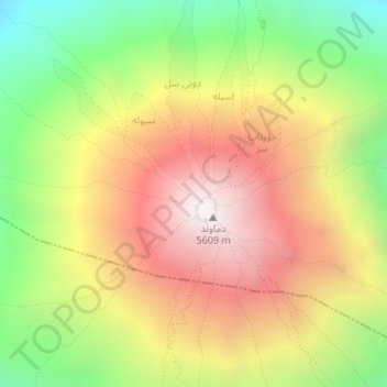
Nome: Mapa topográfico Alborz Mountains, altitude, relevo.
Altitude média: 4934 m
Altitude mínima: 4249 m
Altitude máxima: 5595 m
Faça uma doação
Prepare-se para a sua próxima aventura:
Como Associado da Amazon, este site recebe uma comissão sobre compras elegíveis sem custo adicional para si.