
Faça uma doação
Prepare-se para a sua próxima aventura:
Como Associado da Amazon, este site recebe uma comissão sobre compras elegíveis sem custo adicional para si.
Mapa topográfico Hillsboro
Clique no mapa para exibir a altitude.
Faça uma doação
Prepare-se para a sua próxima aventura:
Como Associado da Amazon, este site recebe uma comissão sobre compras elegíveis sem custo adicional para si.
Hillsboro
The United States Census Bureau reports the city has a total area of 21.6 sq mi (55.9 km2), all of which is land. In 2013, Hillsboro itself reported an area of 23.88 sq mi (61.8 km2), equivalent to 15,283 acres (61.8 km2). The city is located in the Tualatin Valley, and the Tualatin River forms part of the southern city limits. The city's terrain is fairly level, consistent with an agricultural past and the farms still in operation. Hillsboro is about 17 mi (27 km) west of Portland and immediately west of Beaverton, at an elevation of 194 ft (59 m) above sea level. In addition to the Tualatin River, streams include Dairy Creek, McKay Creek, Rock Creek, Dawson Creek, and Turner Creek. Neighboring communities in addition to Beaverton are Aloha, Cornelius, Glencoe, North Plains, Reedville, Scholls, and West Union.
Faça uma doação
Prepare-se para a sua próxima aventura:
Como Associado da Amazon, este site recebe uma comissão sobre compras elegíveis sem custo adicional para si.
Sobre este mapa
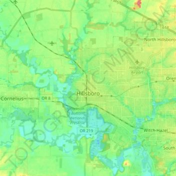
Nome: Mapa topográfico Hillsboro, altitude, relevo.
Local: Hillsboro, Washington County, Oregon, United States (45.47636 -123.01181 45.57652 -122.85954)
Altitude média: 53 m
Altitude mínima: 33 m
Altitude máxima: 93 m
Faça uma doação
Prepare-se para a sua próxima aventura:
Como Associado da Amazon, este site recebe uma comissão sobre compras elegíveis sem custo adicional para si.
Outros mapas topográficos
Clique em um mapa para visualizar sua topografia, sua altitude e seu relevo.
Faça uma doação
Prepare-se para a sua próxima aventura:
Como Associado da Amazon, este site recebe uma comissão sobre compras elegíveis sem custo adicional para si.
Vern Galaway Memorial Park
United States > Oregon > Washington County > North Plains
Altitude média: 56 m