
Faça uma doação
Prepare-se para a sua próxima aventura:
Como Associado da Amazon, este site recebe uma comissão sobre compras elegíveis sem custo adicional para si.
Mapa topográfico Airport Road
Clique no mapa para exibir a altitude.
Faça uma doação
Prepare-se para a sua próxima aventura:
Como Associado da Amazon, este site recebe uma comissão sobre compras elegíveis sem custo adicional para si.
Sobre este mapa
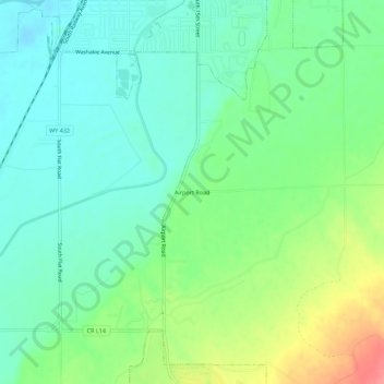
Nome: Mapa topográfico Airport Road, altitude, relevo.
Altitude média: 1257 m
Altitude mínima: 1232 m
Altitude máxima: 1309 m
Faça uma doação
Prepare-se para a sua próxima aventura:
Como Associado da Amazon, este site recebe uma comissão sobre compras elegíveis sem custo adicional para si.
Outros mapas topográficos
Clique em um mapa para visualizar sua topografia, sua altitude e seu relevo.
Worland
United States > Wyoming > Washakie County
Due to the location within the Big Horn Basin, it is protected from severe weather by the surrounding mountains from nearly every direction. This topography results in weather that is highly continental with frigid and dry winters, little wind, little rainfall and few storms. Worland is the least windy…
Altitude média: 1268 m