
Mapa topográfico Little Current
Mapa interativo
Clique no mapa para exibir a altitude.
Sobre este mapa
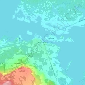
Nome: Mapa topográfico Little Current, altitude, relevo.
Altitude média: 193 m
Altitude mínima: 172 m
Altitude máxima: 329 m
Outros mapas topográficos
Clique em um mapa para visualizar sua topografia, sua altitude e seu relevo.
Rabbit Island
Canada > Ontario > Manitoulin District > Northeastern Manitoulin and the Islands
Rabbit Island, Northeastern Manitoulin and the Islands, Manitoulin District, Northeastern Ontario, Ontario, Canada
Altitude média: 187 m
McKenzie Island
Canada > Ontario > Manitoulin District > Northeastern Manitoulin and the Islands
McKenzie Island, Northeastern Manitoulin and the Islands, Manitoulin District, Northeastern Ontario, Ontario, Canada
Altitude média: 210 m