
Mapa topográfico County Limerick
Mapa interativo
Clique no mapa para exibir a altitude.
Sobre este mapa
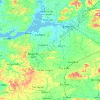
Nome: Mapa topográfico County Limerick, altitude, relevo.
Local: County Limerick, Munster, Ireland (52.28020 -9.36543 52.69629 -8.15637)
Altitude média: 107 m
Altitude mínima: -2 m
Altitude máxima: 688 m
One possible meaning for the county's name in Irish Luimneach is "the flat area"; this description is accurate as the land consists mostly of a fertile limestone plain. Moreover, the county is ringed by mountains: the Slieve Felims to the northeast, the Galtees to the southeast, the Ballyhoura Mountains to the south, and the Mullaghareirk Mountains to the southwest and west. The highest point in the county is located in its southeast corner at Galtymore (919 m), which separates Limerick from County Tipperary. Limerick shares the 3rd-highest county peak in Ireland with Tipperary. The county is not simply a plain, its topography consists of hills and ridges. The eastern part of the county is part of the Golden Vale, which is well known for dairy produce and consists of rolling low hills. This gives way to very flat land around the centre of the county, with the exception being Knockfierna at 288 m high. Towards the west, the Mullaghareirk Mountains (Mullach an Radhairc in Irish, roughly meaning "mountains of the view") push across the county offering extensive views east over the county and west into County Kerry.
Outros mapas topográficos
Clique em um mapa para visualizar sua topografia, sua altitude e seu relevo.
Kilmihil
Kilmihil, West Clare Municipal District, County Clare, Munster, Ireland
Altitude média: 69 m
Carrigaholt
Carrigaholt, West Clare Municipal District, County Clare, Munster, Ireland
Altitude média: 15 m
Newquay
Newquay, Abbey ED, West Clare Municipal District, County Clare, Munster, Ireland
Altitude média: 7 m
Culleenatreen
Culleenatreen, Danesfort ED, Boyle Municipal District, County Roscommon, Connacht, Ireland
Altitude média: 65 m
Kilgobbin
Kilgobbin, Ballinadee ED, The Municipal District of Bandon-Kinsale, County Cork, Munster, Ireland
Altitude média: 85 m
Kilgobbin
Ireland > County Dublin > Stepaside
Kilgobbin, Glencullen Electoral Division, Stepaside, Dún Laoghaire-Rathdown, County Dublin, Leinster, Ireland
Altitude média: 143 m
Rathcormack
Rathcormack, Drumcliff South, Drumcliff West ED, Sligo Municipal Borough District, County Sligo, Connacht, F91 PY24, Ireland
Altitude média: 27 m
Galway City
Galway, Galway City, County Galway, Connacht, H91 YD86, Ireland
Altitude média: 26 m
Kilrush
Kilrush, West Clare Municipal District, County Clare, Munster, Ireland
Altitude média: 22 m
Glenfarne
Glenfarne, Glenfarn ED, Manorhamilton Municipal District, County Leitrim, Connacht, Ireland
Altitude média: 90 m
Slaney
Slaney, Newtownbarry ED, The Municipal District of Enniscorthy, County Wexford, Leinster, Y21 E1T6, Ireland
Altitude média: 50 m
Johnstown
Johnstown, The Municipal District of Naas, County Kildare, Leinster, W91 Y3CP, Ireland
Altitude média: 97 m
Ballybrack
Ballybrack, Moville ED, Inishowen Municipal District, County Donegal, Ireland
Altitude média: 147 m
Conaghy
Conaghy, Killeevan ED, Ballybay-Clones Municipal District, County Monaghan, Ulster, Ireland
Altitude média: 67 m
Ballyseedy Wood
Ballyseedy Wood, Ballyseedy ED, Tralee Municipal District, County Kerry, Munster, Ireland
Altitude média: 20 m
Kilkenny
Kilkenny, The Municipal District of Kilkenny City, County Kilkenny, Leinster, Ireland
Altitude média: 61 m
Summerhill
Summerhill, Summerhill ED, The Municipal District of Trim, County Meath, Leinster, Ireland
Altitude média: 86 m
Sligo
Sligo, Sligo Municipal Borough District, County Sligo, Connacht, Ireland
Altitude média: 21 m
Moyglare
Moyglare, Rodanstown ED, The Municipal District of Ratoath, County Meath, Leinster, W23 RT91, Ireland
Altitude média: 66 m
Dromore West
Dromore West, Ballymote-Tubbercurry Municipal District, County Sligo, Connacht, Ireland
Altitude média: 51 m
Morristown
Morristown, Rathmore ED, The Municipal District of Naas, County Kildare, Leinster, Ireland
Altitude média: 113 m
Gort
Gort, Loughrea Municipal District, County Galway, Connacht, H91 R5F9, Ireland
Altitude média: 27 m
Cloonkeenkerrill
Cloonkeenkerrill, Colmanstown ED, Ballinasloe Municipal District, County Galway, Connacht, Ireland
Altitude média: 88 m
Smithstown
Smithstown, Ballinlough ED, The Municipal District of Kells, County Meath, Leinster, Ireland
Altitude média: 121 m
Colmanstown
Colmanstown, Killofin ED, West Clare Municipal District, County Clare, Munster, Ireland
Altitude média: 24 m
Cahir
Cahir, The Municipal District of Cahir — Cashel, County Tipperary, Munster, Ireland
Altitude média: 58 m
Broadlough
Broadlough, Ardee Rural ED, The Municipal District of Ardee, County Louth, Leinster, Ireland
Altitude média: 34 m
Cordarragh
Cordarragh, Headford ED, Tuam Municipal District, County Galway, Connacht, Ireland
Altitude média: 20 m
Ballincollig
Ireland > County Cork > Cork
Ballincollig, Cork, County Cork, Munster, P31 TW88, Ireland
Altitude média: 62 m
Ballinaclogh
Ballinaclogh, Glenealy ED, The Municipal District of Wicklow, County Wicklow, Leinster, Ireland
Altitude média: 108 m
Lanesborough
Lanesborough, Ballymahon Municipal District, County Longford, Leinster, Ireland
Altitude média: 41 m
Lough Bane
Lough Bane, Crosskeys ED, The Municipal District of Kells, County Westmeath, County Meath, Leinster, Ireland
Altitude média: 130 m
Curraghboy
Curraghboy, Rockhill Electoral Division, Athlone Municipal District, County Roscommon, Connacht, N37 EK20, Ireland
Altitude média: 69 m
Pembrokestown
Pembrokestown, Waterford City Metropolitan District, County Waterford, Munster, X91 R6CA, Ireland
Altitude média: 57 m
Comeragh
Comeragh, The Municipal District of Comeragh, County Waterford, Munster, Ireland
Altitude média: 215 m
Adare
Ireland > County Limerick > The Municipal District of Adare — Rathkeale
Adare, The Municipal District of Adare — Rathkeale, County Limerick, Munster, Ireland
Altitude média: 12 m
Ballivor
Ballivor, The Municipal District of Trim, County Meath, Leinster, Ireland
Altitude média: 67 m
Kilcurriv Eighter
Kilcurriv Eighter, Killower ED, Tuam Municipal District, County Galway, Connacht, Ireland
Altitude média: 48 m