
Mapa topográfico Kennewick
Mapa interativo
Clique no mapa para exibir a altitude.
Sobre este mapa
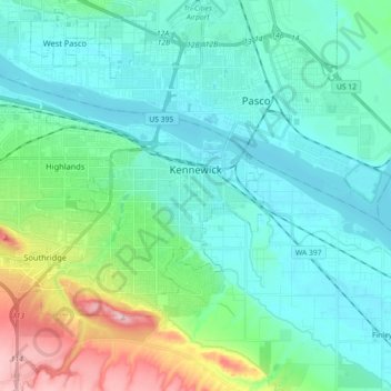
Nome: Mapa topográfico Kennewick, altitude, relevo.
Local: Kennewick, Benton County, Washington, United States (46.16084 -119.26814 46.24016 -119.08714)
Altitude média: 154 m
Altitude mínima: 100 m
Altitude máxima: 363 m
Native Americans populated the area around modern-day Kennewick for millennia before being discovered and settled by European descendants. These inhabitants consisted of people from the Umatilla, Wanapum, Nez Perce, and Yakama tribes. Kennewick's low elevation helped to moderate winter temperatures. On top of this, the riverside location made salmon and other river fish easily accessible. By the 19th century, people lived in and between two major camps in the area. These were located near present-day Sacajawea State Park in Pasco and Columbia Point in Richland. Lewis and Clark noted that there were many people living in the area when they passed through in 1805 and 1806. The map produced following their journey marks two significant villages in the area - Wollawollah and Selloatpallah. These had approximate populations of 2,600 and 3,000 respectively.
Outros mapas topográficos
Clique em um mapa para visualizar sua topografia, sua altitude e seu relevo.
Hanford
United States > Washington > Benton County
Hanford, Benton County, Washington, United States
Altitude média: 123 m
Badger
United States > Washington > Benton County
Badger, Benton County, Washington, United States
Altitude média: 246 m
Kiona
United States > Washington > Benton County
Kiona, Benton County, Washington, 99320, United States
Altitude média: 224 m
North Prosser
United States > Washington > Benton County
North Prosser, Benton County, Washington, 99350, United States
Altitude média: 231 m
Plymouth
United States > Washington > Benton County
Plymouth, Benton County, Washington, 99346, United States
Altitude média: 105 m
Longview
United States > Washington > Benton County
Longview, Benton County, Washington, United States
Altitude média: 99 m
Highland
United States > Washington > Benton County
Highland, Benton County, Washington, United States
Altitude média: 196 m
Whistran Wildlife Area
United States > Washington > Benton County
Whistran Wildlife Area, Benton County, Washington, United States
Altitude média: 233 m
Finley
United States > Washington > Benton County
Finley, Benton County, Washington, United States
Altitude média: 115 m
Paterson
United States > Washington > Benton County
Paterson, Benton County, Washington, United States
Altitude média: 125 m
Benton City
United States > Washington > Benton County
Benton City, Benton County, Washington, United States
Altitude média: 190 m
West Richland
United States > Washington > Benton County
West Richland, Benton County, Washington, 99353, United States
Altitude média: 146 m
Kennewick
United States > Washington > Benton County > Kennewick
Kennewick, Benton County, Washington, 99337, United States
Altitude média: 224 m
Prosser
United States > Washington > Benton County > Prosser > Prosser
Prosser, Benton County, Washington, 99350-1300, United States
Altitude média: 294 m
Richland
United States > Washington > Benton County
Richland, Benton County, Washington, United States
Altitude média: 160 m
Prosser
United States > Washington > Benton County
Prosser, Benton County, Washington, 99350, United States
Altitude média: 280 m
Audrey
United States > Washington > Benton County
Audrey, Benton County, Washington, United States
Altitude média: 156 m