
Mapa topográfico Ione
Mapa interativo
Clique no mapa para exibir a altitude.
Sobre este mapa
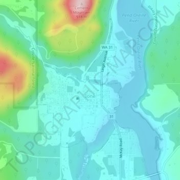
Nome: Mapa topográfico Ione, altitude, relevo.
Altitude média: 670 m
Altitude mínima: 614 m
Altitude máxima: 907 m
Ione is situated on the west bank of the Pend Oreille River as it flows north towards Canada. Big Muddy Creek, Little Muddy Creek and Cedar Creek, from south to north, join the river in Ione. State Route 31 passes through town. Ione Bridge, on the southern edge of town, is the only road crossing of the Pend Oreille between Metaline Falls to the north and Usk to the south. Being located in the Selkirk Mountains, the area immediately surrounding Ione is of high topographic relief. The town itself is on a relatively flat area along the river at an elevation of 2,090 feet above sea level, but the mountains rise dramatically both sides of the Pend Oreille. Cement Mountain, with its peak roughly a mile immediately north of town, rises to 3,003 feet. Molybdenite Mountain, across the river from Ione, rises even higher to 6,788 feet.
Outros mapas topográficos
Clique em um mapa para visualizar sua topografia, sua altitude e seu relevo.
Pend Orielle River
United States > Washington > Pend Oreille County
Pend Orielle River, Pend Oreille County, Washington, 83822, United States
Altitude média: 1060 m
Metaline
United States > Washington > Pend Oreille County
Metaline, Pend Oreille County, Washington, 99152, United States
Altitude média: 713 m
Deer Valley
United States > Washington > Pend Oreille County > Deer Valley
Deer Valley, Pend Oreille County, Washington, United States
Altitude média: 724 m
Kalispel Reservation
United States > Washington > Pend Oreille County > Airway Heights
Kalispel Reservation, Airway Heights, Pend Oreille County, Washington, United States
Altitude média: 801 m
Metaline Falls
United States > Washington > Pend Oreille County
Metaline Falls, Pend Oreille County, Washington, 99153, United States
Altitude média: 720 m
Pend Oreille Mine Tailings Pond Dam
United States > Washington > Pend Oreille County
Pend Oreille Mine Tailings Pond Dam, Pend Oreille County, Washington, 99153, United States
Altitude média: 741 m
Mill Creek Point
United States > Washington > Pend Oreille County
Mill Creek Point, Pend Oreille County, Washington, United States
Altitude média: 1275 m