
Mapa topográfico Guangzhou City
Mapa interativo
Clique no mapa para exibir a altitude.
Sobre este mapa
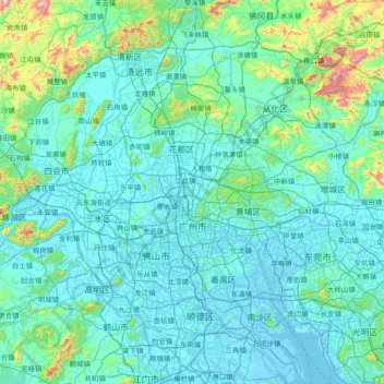
Nome: Mapa topográfico Guangzhou City, altitude, relevo.
Local: Guangzhou City, Guangdong Province, China (22.56080 112.95237 23.93566 114.05476)
Altitude média: 98 m
Altitude mínima: -10 m
Altitude máxima: 1236 m
The elevation of the prefecture generally increases from southwest to northeast, with mountains forming the backbone of the city and the ocean comprising the front. Tiantang Peak (simplified Chinese: 天堂顶; traditional Chinese: 天堂頂, "Heavenly Peak") is the highest point of elevation at 1,210 m (3,970 ft) above sea level.
Outros mapas topográficos
Clique em um mapa para visualizar sua topografia, sua altitude e seu relevo.
Dongguan
China > Guangdong Province > Dongguan
Dongguan, Guangdong Province, 523058, China
Altitude média: 20 m
Shaxi
China > Guangdong Province > Zhongshan > Shaxi > Shenmingtingcun
Shaxi, Zhongshan, Shenmingtingcun, Guangdong Province, China
Altitude média: 8 m
Hangcheng Sub-district
China > Guangdong Province > Bao'an District > Hangcheng Sub-district
Hangcheng Sub-district, Bao'an District, Shenzhen, Guangdong Province, 518100, China
Altitude média: 21 m