
Mapa topográfico Jammu and Kashmir
Mapa interativo
Clique no mapa para exibir a altitude.
Sobre este mapa
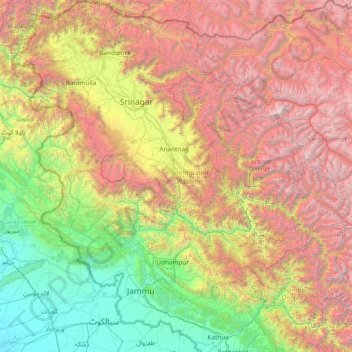
Nome: Mapa topográfico Jammu and Kashmir, altitude, relevo.
Local: Jammu and Kashmir, India (32.27636 73.75003 34.78714 76.78032)
Altitude média: 2430 m
Altitude mínima: 208 m
Altitude máxima: 7015 m
Jammu and Kashmir is home to several valleys such as the Kashmir Valley, Tawi Valley, Chenab Valley, Poonch Valley, Sind Valley, and Lidder Valley. The Kashmir valley is 100 km (62 mi) wide and 15,520.3 km2 (5,992.4 sq mi) in area. The Himalayas divide the Kashmir valley from the Tibetan plateau while the Pir Panjal range, which encloses the valley from the west and the south, separates it from the Punjab Plain of the Indo-Gangetic Plain. Along the northeastern flank of the Valley runs the main range of the Himalayas. This valley has an average height of 1,850 metres (6,070 ft) above sea-level, but the surrounding Pir Panjal range has an average elevation of 10,000 feet (3,000 m). The Jhelum River is the major Himalayan river which flows through the Kashmir valley. The southern Jammu region is mostly mountainous, with the Shivaliks, the middle and the great Himalayas running parallel to each other in a southeast-northwest direction. A narrow southwestern strip constitutes fertile plains. The Chenab, Tawi and Ravi are important rivers flowing through the Jammu region.
Outros mapas topográficos
Clique em um mapa para visualizar sua topografia, sua altitude e seu relevo.
Bengaluru
India > Karnataka > Bangalore North
Bengaluru, Bangalore North, Bengaluru Urban District, Karnataka, India
Altitude média: 881 m
Varanasi
India > Uttar Pradesh > Sadar
Varanasi, Sadar, Varanasi District, Uttar Pradesh, 221001, India
Altitude média: 77 m
3d
India > Rajasthan > Ganganagar Tehsil > 1 LNP
3d, 1 LNP, Ganganagar Tehsil, Sri Ganganagar District, Rajasthan, India
Altitude média: 178 m
Pune
India > Maharashtra > Pune City > Pune
Pune, Pune City, Pune District, Maharashtra, 411001, India
Altitude média: 641 m
Bachupally mandal
Bachupally mandal, Medchal–Malkajgiri District, Telangana, 500090, India
Altitude média: 593 m
Western Ghats
Western Ghats, Idukki, Kerala, 685614, India
Altitude média: 2225 m
Dharapathaguli
India > Uttarakhand > Kosya Kutauli > banjbari
Dharapathaguli, banjbari, Kosya Kutauli, Nainital District, Uttarakhand, 263137, India
Altitude média: 1571 m
Whitefield
India > Karnataka > Bangalore East > Bengaluru
Whitefield, Bengaluru, Bangalore East, Bengaluru Urban District, Karnataka, 560066, India
Altitude média: 875 m
Gurgaon
India > Haryana > Gurugram District
Gurgaon, Gurugram District, Haryana, India
Altitude média: 237 m
Thiruvananthapuram
India > Kerala > Thiruvananthapuram
Thiruvananthapuram, Thiruvananthapuram District, Kerala, 695001, India
Altitude média: 33 m
Srinagar
India > Jammu and Kashmir > Srinagar (South)
Srinagar, Srinagar (South), Srinagar District, Jammu and Kashmir, 190001, India
Altitude média: 1805 m
Lucknow
India > Uttar Pradesh > Lucknow
Lucknow, Lucknow District, Uttar Pradesh, 226027, India
Altitude média: 120 m
Durha
India > Madhya Pradesh > Unchahara Tahsil > Dudaha
Durha, Dudaha, Unchahara Tahsil, Satna District, Madhya Pradesh, India
Altitude média: 343 m
Chandauli
Chandauli, Chandauli District, Uttar Pradesh, India
Altitude média: 75 m
Kachohalli
India > Karnataka > Bangalore North
Kachohalli, Bangalore North, Bengaluru Urban, Karnataka, 560018, India
Altitude média: 868 m
Gangodanahalli
India > Karnataka > Bangalore North
Gangodanahalli, Bangalore North, Bengaluru Urban, Karnataka, 560018, India
Altitude média: 865 m
Sheoganj
India > Rajasthan > Sheoganj Tehsil
Sheoganj, Sheoganj Tehsil, Sirohi District, Rajasthan, 306902, India
Altitude média: 271 m
Mysuru
India > Karnataka > Mysuru taluk
Mysuru, Mysuru taluk, Mysuru District, Karnataka, 570001, India
Altitude média: 727 m
Shimla
India > Himachal Pradesh > Shimla (urban)
Shimla, Shimla (urban), Shimla District, Himachal Pradesh, 171001, India
Altitude média: 1557 m