
Mapa topográfico Red Wing
Mapa interativo
Clique no mapa para exibir a altitude.
Sobre este mapa
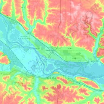
Nome: Mapa topográfico Red Wing, altitude, relevo.
Local: Red Wing, Goodhue County, Minnesota, United States (44.52796 -92.67277 44.66966 -92.46723)
Altitude média: 263 m
Altitude mínima: 199 m
Altitude máxima: 353 m
According to the United States Census Bureau, the city has an area of 41.19 square miles (106.68 km2), of which 34.60 square miles (89.61 km2) is land and 6.59 square miles (17.07 km2) is water. The city is at the northern edge of the Driftless Area of karst topography.
Outros mapas topográficos
Clique em um mapa para visualizar sua topografia, sua altitude e seu relevo.
Zumbrota
United States > Minnesota > Goodhue County
Zumbrota, Goodhue County, Minnesota, 55992, United States
Altitude média: 312 m
Kenyon
United States > Minnesota > Goodhue County
Kenyon, Goodhue County, Minnesota, United States
Altitude média: 351 m
Dennison
United States > Minnesota > Goodhue County
Dennison, Goodhue County, Minnesota, United States
Altitude média: 303 m
Frontenac
United States > Minnesota > Goodhue County
Frontenac, Florence Township, Goodhue County, Minnesota, 55026, United States
Altitude média: 243 m
Goodhue
United States > Minnesota > Goodhue County
Goodhue, Goodhue County, Minnesota, 55027, United States
Altitude média: 346 m
Wanamingo
United States > Minnesota > Goodhue County
Wanamingo, Goodhue County, Minnesota, 55983, United States
Altitude média: 325 m
Pine Island
United States > Minnesota > Goodhue County
Pine Island, Goodhue County, Minnesota, United States
Altitude média: 327 m
Welch
United States > Minnesota > Goodhue County
Welch, Welch Township, Goodhue County, Minnesota, United States
Altitude média: 277 m
Cannon Falls
United States > Minnesota > Goodhue County > Cannon Falls > Cannon Falls
Cannon Falls, Goodhue County, Minnesota, 55009, United States
Altitude média: 268 m
Cannon Falls
United States > Minnesota > Goodhue County
Cannon Falls, Goodhue County, Minnesota, 55009, United States
Altitude média: 276 m