
Mapa topográfico Wenzhou
Mapa interativo
Clique no mapa para exibir a altitude.
Sobre este mapa
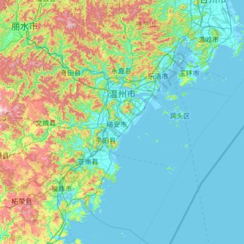
Nome: Mapa topográfico Wenzhou, altitude, relevo.
Local: Wenzhou, Zhejiang, China (26.96481 119.62023 28.61525 121.55736)
Altitude média: 217 m
Altitude mínima: -4 m
Altitude máxima: 1483 m
Most of Wenzhou's landscape is mountainous, with many mountain tops reaching altitudes in excess of 1,000 m (3,300 ft), for example in the Yandang Mountains, a coastal mountain range dominating the eastern part of prefecture. Another dominating landscape element is the Ou River, the largest river in Wenzhou prefecture. There are some coastal plains, notably around the mouth of the Ou (where the city proper of Wenzhou is located), the Nanxi River, a tributary of the Ou, and further south, around the mouth of the Feiyun River (in Rui'an, a county-level city). Coastal plains are used intensively for agriculture but also host much of the population and industry.
Outros mapas topográficos
Clique em um mapa para visualizar sua topografia, sua altitude e seu relevo.
Yandang Mountain Nanhe Archway Group
Yandang Mountain Nanhe Archway Group, 南閤村, Yueqing, Wenzhou, Zhejiang, 325616, China
Altitude média: 126 m
大洲镇
China > Zhejiang > Qujiang District
大洲镇, Qujiang District, Quzhou, Zhejiang, China
Altitude média: 577 m
Liucheng
China > Zhejiang > Wuyi County
Liucheng, Wuyi County, Jinhua, Zhejiang, China
Altitude média: 494 m
Luqiao District
Luqiao District, Taizhou, Zhejiang, 318050, China
Altitude média: 64 m
Pingyang County
China > Zhejiang > Pingyang County
Pingyang County, Wenzhou, Zhejiang, China
Altitude média: 165 m
Yuecheng District
Yuecheng District, Shaoxing, Zhejiang, 312000, China
Altitude média: 45 m
North Peak
China > Zhejiang > Xihu District
North Peak, Xihu District, Zhejiang, 310013, China
Altitude média: 110 m