
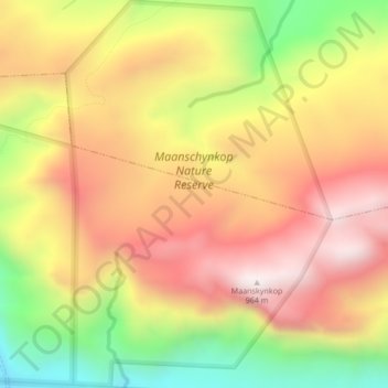
Mapa topográfico Maanschynkop Nature Reserve
Mapa interativo
Clique no mapa para exibir a altitude.
Sobre este mapa
Nome: Mapa topográfico Maanschynkop Nature Reserve, altitude, relevo.
Altitude média: 538 m
Altitude mínima: 14 m
Altitude máxima: 953 m
Outros mapas topográficos
Clique em um mapa para visualizar sua topografia, sua altitude e seu relevo.
Overstrand Ward 8
RSA > Western Cape > Overstrand Local Municipality
Overstrand Ward 8, Overstrand Local Municipality, Overberg District Municipality, Western Cape, RSA
Altitude média: 144 m
Walker Bay Nature Reserve
RSA > Western Cape > Overstrand Local Municipality
Walker Bay Nature Reserve, Overstrand Ward 11, Overstrand Local Municipality, Overberg District Municipality, Western Cape, RSA
Altitude média: 54 m
Overstrand Ward 10
RSA > Western Cape > Overstrand Local Municipality
Overstrand Ward 10, Overstrand Local Municipality, Overberg District Municipality, Western Cape, 7141, RSA
Altitude média: 213 m
Rooiels River
RSA > Western Cape > Overstrand Local Municipality
Rooiels River, Overstrand Local Municipality, Overberg District Municipality, Western Cape, RSA
Altitude média: 103 m
Fernkloof Nature Reserve
RSA > Western Cape > Overstrand Local Municipality
Fernkloof Nature Reserve, Rotary Way Extension, Overstrand Ward 3, Overstrand Local Municipality, Overberg District Municipality, Western Cape, 7200, RSA
Altitude média: 237 m
Three Sisters
RSA > Western Cape > Overstrand Local Municipality
Three Sisters, Overstrand Local Municipality, Overberg District Municipality, Western Cape, 7195, RSA
Altitude média: 306 m
Salmonsdam Nature Reserve
RSA > Western Cape > Overstrand Local Municipality
Salmonsdam Nature Reserve, Salmonsdam Nature Reserve 4x4 Trail, Cape Agulhas Ward 1, Overstrand Local Municipality, Overberg District Municipality, Western Cape, RSA
Altitude média: 343 m
Boesmans River
RSA > Western Cape > Overstrand Local Municipality
Boesmans River, Overstrand Local Municipality, Overberg District Municipality, Western Cape, 7271, RSA
Altitude média: 121 m
Quoin Point Nature Reserve
RSA > Western Cape > Overstrand Local Municipality
Quoin Point Nature Reserve, R43, Overstrand Ward 11, Overstrand Local Municipality, Overberg District Municipality, Western Cape, RSA
Altitude média: 12 m