
Mapa topográfico Sibu
Mapa interativo
Clique no mapa para exibir a altitude.
Sibu
Sibu is located near the Rajang delta at the confluence of Rajang and Igan rivers. Peat swamp forests and alluvial plains are particularly prevalent in the Sibu Division. Sibu is located on a deep peat soil, which has caused problems in infrastructure development because buildings and roads slowly sink into the ground after its completion. The location of Sibu in lowland peat swamps have subjected it to frequent floods, about 1 to 3 times per year. Because of these factors, the Sibu Flood Mitigation project was started to relieve the area from the floods. The highest elevation in Sibu is at Bukit Aup Jubilee Park, measuring 59 m above sea level.
Sobre este mapa
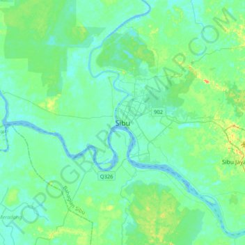
Nome: Mapa topográfico Sibu, altitude, relevo.
Local: Sibu, Sibu Division, Sarawak, 96000, Malaysia (2.13064 111.66562 2.45064 111.98562)
Altitude média: 10 m
Altitude mínima: -4 m
Altitude máxima: 55 m
Outros mapas topográficos
Clique em um mapa para visualizar sua topografia, sua altitude e seu relevo.
Sibu
Malaysia > Sarawak > Sibu > Sibu
Sibu is located near the Rajang delta at the confluence of Rajang and Igan rivers. Peat swamp forests and alluvial plains are particularly prevalent in the Sibu Division. Sibu is located on a deep peat soil, which has caused problems in infrastructure development because buildings and roads slowly sink into…
Altitude média: 9 m